
Xinjiang Petroleum Geology ›› 2024, Vol. 45 ›› Issue (2): 244-252.doi: 10.7657/XJPG20240214
• APPLICATION OF TECHNOLOGY • Previous Articles
PENG Gengxin1( ), GU Xiaodi2, DUAN Wensheng1, GONG Ting2, ZHAO Ruirui1, WANG Qing2
Received:2023-07-29
Revised:2023-11-03
Online:2024-04-01
Published:2024-03-26
CLC Number:
PENG Gengxin, GU Xiaodi, DUAN Wensheng, GONG Ting, ZHAO Ruirui, WANG Qing. Application of True Surface Velocity Modeling Technology to Imaging of Seismic Data in Complex Mountainous Areas[J]. Xinjiang Petroleum Geology, 2024, 45(2): 244-252.
Add to citation manager EndNote|Reference Manager|ProCite|BibTeX|RefWorks
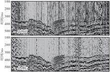
Fig. 1.
Single-shot image (a) before and (b) after first-arrival optimization"
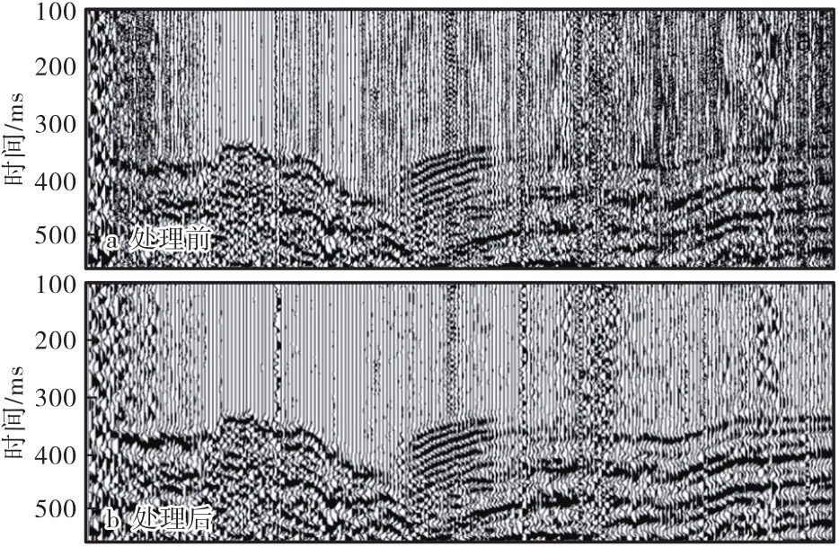
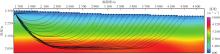
Fig. 2.
Ray paths for different offsets"
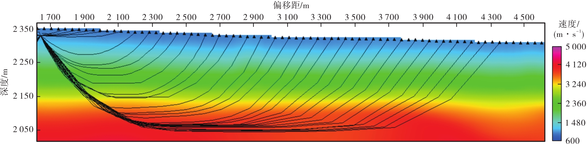
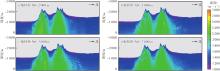
Fig. 3.
Inversion results for different offsets"
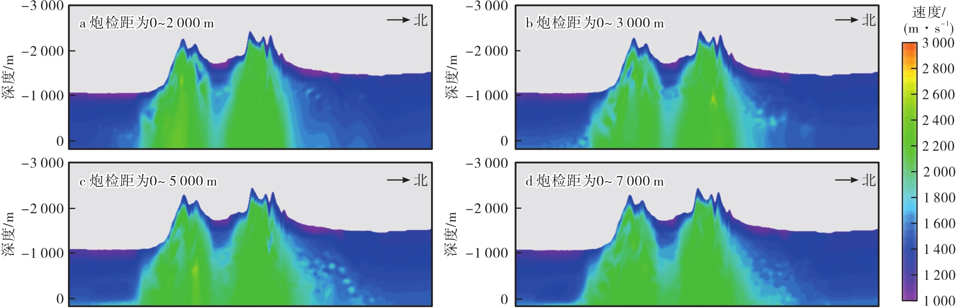
Fig. 4.
(a) Near-surface velocity model based on two-step constrained tomography inversion and (b) comparison between inversion velocity and VSP logging velocity"
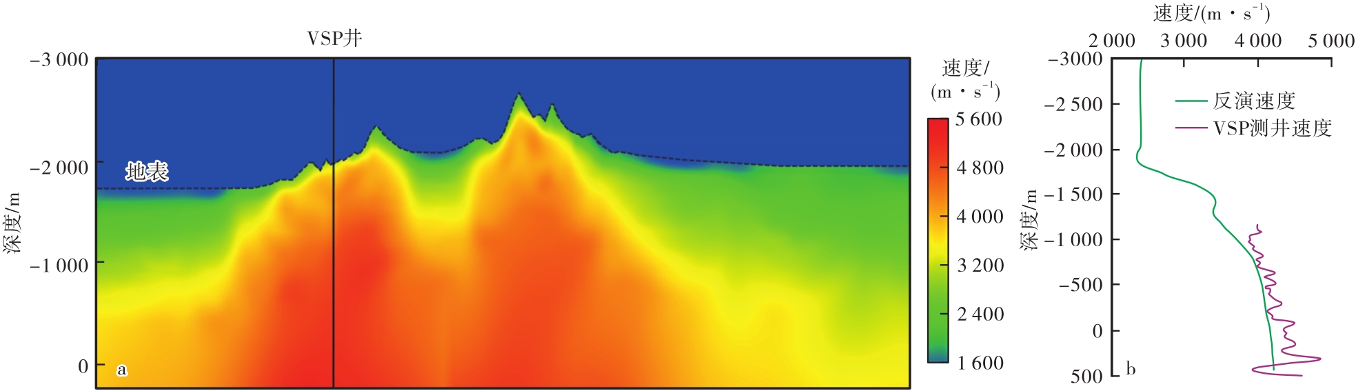
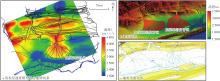
Fig. 5.
Pattern recognition using near-surface velocity model with high-resolution geological outcrop projection"
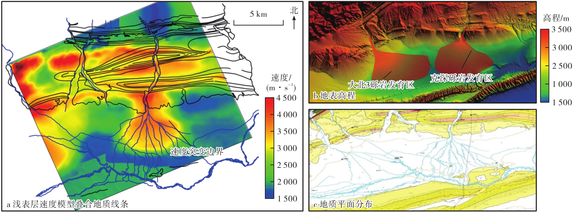
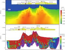
Fig. 6.
(a) Near-surface velocity model and (b) ray density analysis"
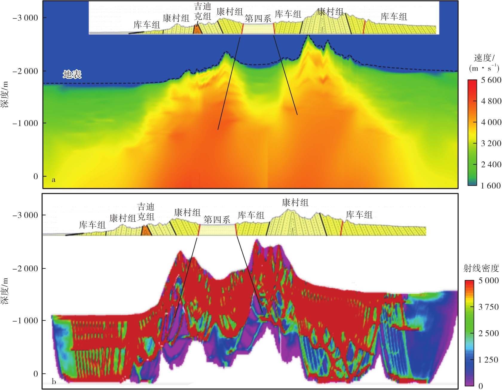

Fig. 7.
Velocity models before and after optimization"
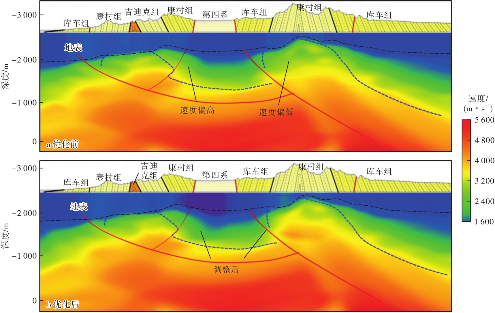
Fig. 8.
Migration sections before and after velocity optimization"
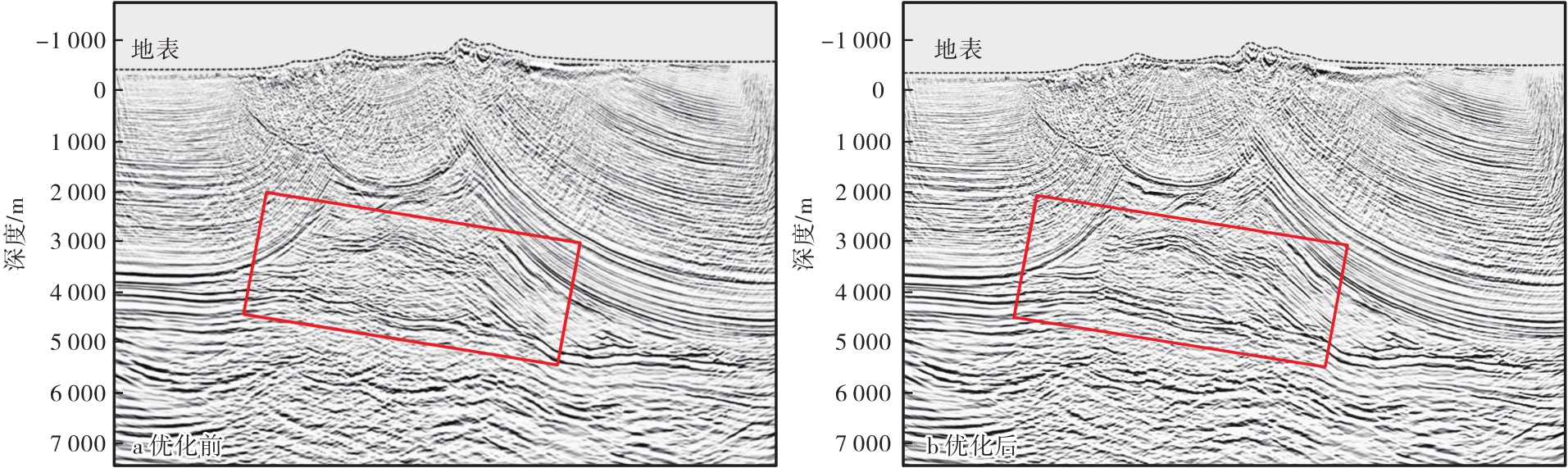
Fig. 9.
Comparison between even surface migration and true surface migration"
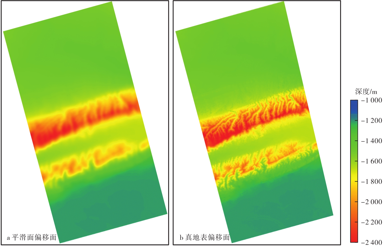
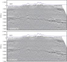
Fig. 10.
Sections of input traces of (a) conventional depth migration and (b) true surface migration"

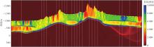
Fig. 11.
Ray density from tomography inversion"
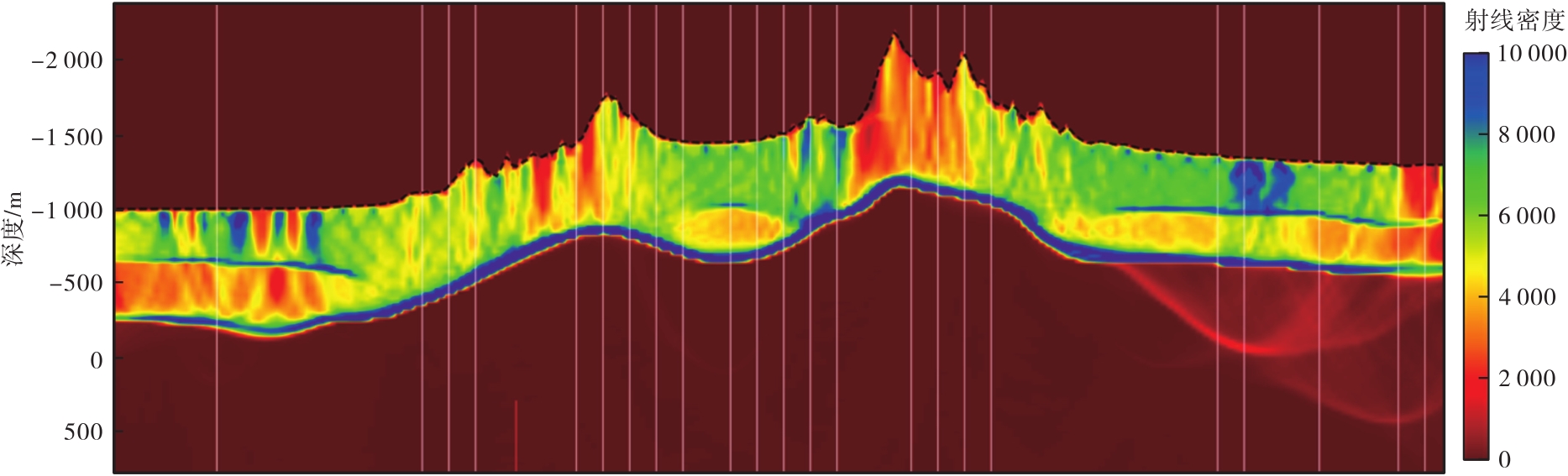

Fig. 12.
Full-depth velocity model integrated with near-surface velocity"
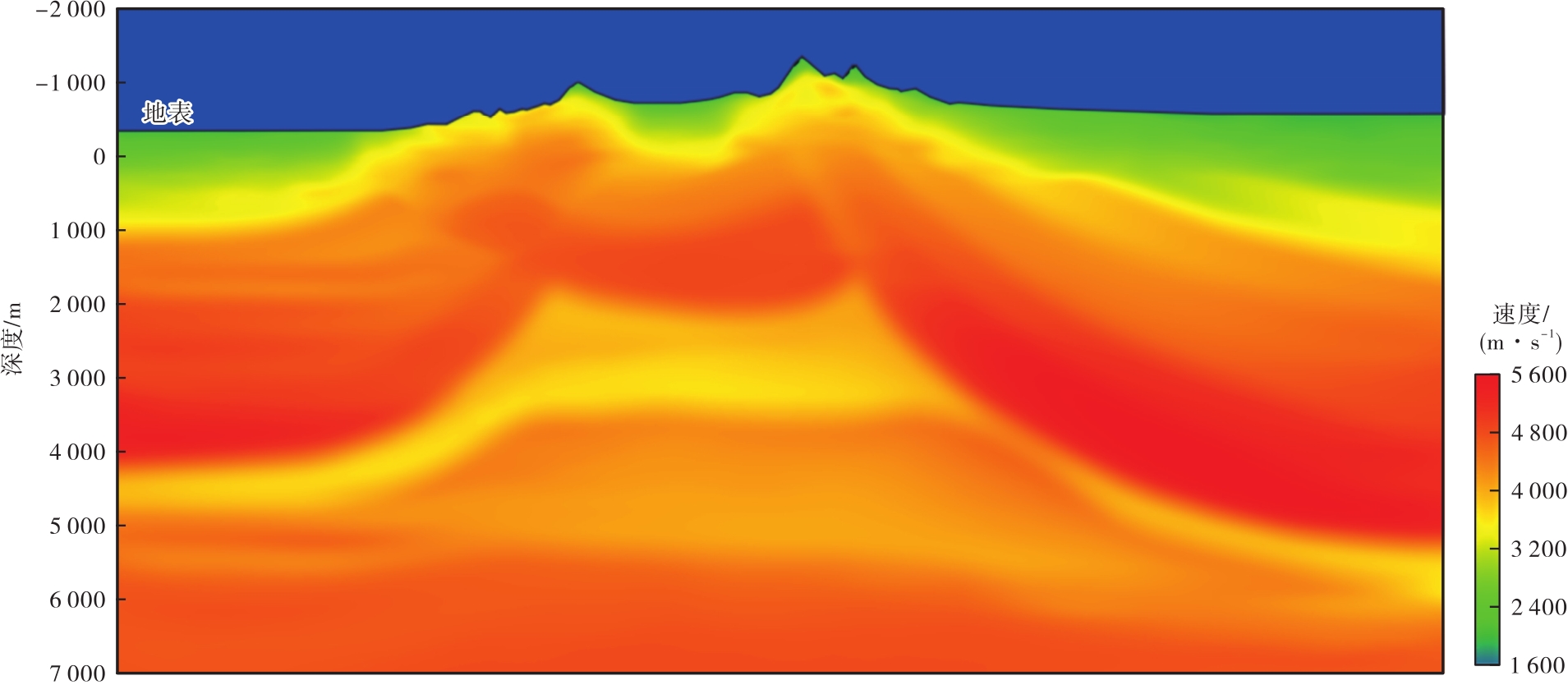
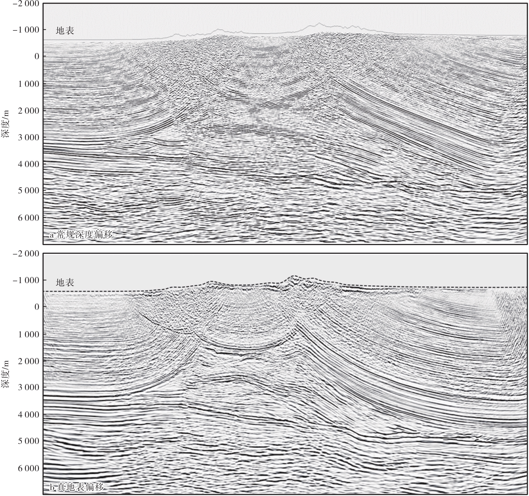
Fig. 13.
Imaging sections of (a) conventional depth migration and (b) true surface migration"
| [1] | 苟量, 贺振华. 西部复杂山地勘探走势分析[J]. 石油地球物理勘探, 2005, 40(2):248-251. |
| GOU Liang, HE Zhenhua. Analysis of trend to complex mountainous exploration in west of China[J]. Oil Geophysical Prospecting, 2005, 40(2):248-251. | |
| [2] | 方勇, 罗文山, 姜翠苹, 等. 库车山地地震资料层析静校正方法的应用[J]. 石油地球物理勘探, 2017, 52(增刊1):23-27. |
| FANG Yong, LUO Wenshan, JIANG Cuiping, et al. Tomo-statics for Kuqa seismic data[J]. Oil Geophysical Prospecting, 2017, 52(Supp. 1):23-27. | |
| [3] | 冯泽元, 李培明, 唐海忠, 等. 利用层析反演技术解决山地复杂区静校正问题[J]. 石油物探, 2005, 44(3):284-287. |
| FENG Zeyuan, LI Peiming, TANG Haizhong, et al. Sloving the static correction problem in mountain complex block using tomographic inversion[J]. Geophysical Prospecting for Petroleum, 2005, 44(3):284-287. | |
| [4] |
伍泽云. 零入射角地震资料在 HX 地区薄储层预测中的应用[J]. 特种油气藏, 2022, 29(4):76-83.
doi: 10.3969/j.issn.1006-6535.2022.04.010 |
| WU Zeyun. Application of zero-incidence-angle seismic data to thin reservoir prediction in HX area[J]. Special Oil & Gas Reserviors, 2022, 29(4):76-83. | |
| [5] | 李奎周, 郑绪瑭, 赵海波, 等. 基于波形分解的重构地震数据体技术在致密油薄储层预测中的应用[J]. 大庆石油地质与开发, 2022, 41(4):131-137. |
| LI Kuizhou, ZHENG Xutang, ZHAO Haibo, et al. Application of reconstructed seismic data volume technology based on waveform decomposition in prediction of thin tight oil reservoir[J]. Petroleum Geology & Oilfield Development in Daqing, 2022, 41(4):131-137. | |
| [6] |
赵长永, 陈希光, 李俊飞, 等. 基于三维地震数据的短期旋回内薄层砂体的预测[J]. 特种油气藏, 2023, 30(6):40-47.
doi: 10.3969/j.issn.1006-6535.2023.06.006 |
| ZHAO Changyong, CHEN Xiguang, LI Junfei, et al. Application in the prediction of thin sand body within short-term sequence cycle based on 3D seismic data[J]. Special Oil & Gas Reservoirs, 2023, 30(6):40-47. | |
| [7] | 梁向豪, 李书君, 吴超, 等. 库车大北构造带三维叠前深度偏移处理解释技术[J]. 中国石油勘探, 2011, 16(5/6):8-13. |
| LIANG Xianghao, LI Shujun, WU Chao, et al. 3D prestack depth processing and interpretation in Dabei structure belt,Kuqa depression[J]. China Petroleum Exploration, 2011, 16(5/6):8-13. | |
| [8] | 钱荣均. 复杂地表区时深转换和深度偏移中基准面的问题[J]. 石油地球物理勘探, 1999, 34(6):691-694. |
| QIAN Rongjun. The datum probleum of time-depth conversion and depth migration in complicated-surface area[J]. Oil Geophysical Prospecting, 1999, 34(6):691-694. | |
| [9] | 耿建华, 黄海贵, 马在田. Kirchhoff 积分波场延拓基准面静校正方法研究[J]. 同济大学学报, 1996, 24(6):665-669. |
| GENG Jianhua, HUANG Haigui, MA Zaitian. Kirchhoff wavefield extrapolation datuming[J]. Journal of Tongji University, 1996, 24(6):665-669. | |
| [10] | 蔡杰雄, 杨锴. TDO基准面校正方法研究与应用[J]. 石油地球物理勘探, 2008, 43(4):397-400. |
| CAI Jiexiong, YANG Kai. Study and application of TDO datum correction[J]. Oil Geophysical Prospecting, 2008, 43(4):397-400. | |
| [11] |
刘定进, 刘志成, 蒋波. 面向复杂山前带的深度域地震成像处理研究[J]. 石油物探, 2016, 55(1):49-59.
doi: 10.3969/j.issn.1000-1441.2016.01.007 |
|
LIU Dingjin, LIU Zhicheng, JIANG Bo. The processing workflow of depth domain imaging facing the complex piedmont belt[J]. Geophysical Prospecting for Petroleum, 2016, 55(1):49-59.
doi: 10.3969/j.issn.1000-1441.2016.01.007 |
|
| [12] | 冯许魁. 山前复杂高陡构造地震成像关键技术[D]. 成都: 成都理工大学, 2015. |
| FENG Xukui. The key imaging technology in complex piedmont structure exploration[D]. Chengdu: Chengdu University of Technology, 2015. | |
| [13] | 张继国, 刘连升. 复杂区初至层析反演静校正[J]. 石油地球物理勘探, 2006, 41(4):383-385. |
| ZHANG Jiguo, LIU Liansheng. Static corrections by first breaks tomographic inversion in complex area[J]. Oil Geophysical Prospecting, 2006, 41(4):383-385. | |
| [14] | 秦宁, 李振春, 桑运云, 等. 初至波走时层析速度建模方法研究[J]. 地球物理学进展, 2014, 29(1):225-260. |
| QIN Ning, LI Zhenchun, SANG Yunyun, et al. The research of travel time tomographic velocity modeling method on first break[J]. Progress in Geophysics, 2014, 29(1):255-260. | |
| [15] | 赵烽帆, 马婷, 徐涛. 地震波初至走时的计算方法综述[J]. 地球物理学进展, 2014, 29(3):1102-1113. |
| ZHAO Fengfan, MA Ting, XU Tao. A review of the travel-time calculation methods of seismic first break[J]. Progress in Geophysics, 2014, 29(3):1102-1113. | |
| [16] |
戴海涛, 成剑冰, 王红博, 等. 复杂地表浅层速度建模技术研究及应用[J]. 石油物探, 2020, 59(3):336-343.
doi: 10.3969/j.issn.1000-1441.2020.03.002 |
|
DAI Haitao, CHENG Jianbing, WANG Hongbo, et al. A shallow velocity modeling technique for complex surfaces[J]. Geophysical Prospecting for Petroleum, 2020, 59(3):336-343.
doi: 10.3969/j.issn.1000-1441.2020.03.002 |
|
| [17] | 阿力甫江·热合木吐力, 潘龙, 李献民, 等. 基于双平方根算子的速度建模方法及应用[J]. 新疆石油地质, 2023, 44(1):119-124. |
| Alifjian REHMTULY, PAN Long, LI Xianmin, et al. Development and application of velocity modeling method based on double square root operator[J]. Xinjiang Petroleum Geology, 2023, 44(1):119-124. | |
| [18] | 韩复兴, 孙建国, 孙章庆. 波前构建法研究现状[J]. 地球物理学进展, 2011, 26(3):1045-1051. |
| HAN Fuxing, SUN Jianguo, SUN Zhangqing. Research status of the wavefront construction method[J]. Progress in Geophysics, 2011, 26(3):1045-1051. | |
| [19] | 赵玲芝, 冯许魁, 祖云飞, 等. 复杂地表区叠前深度偏移近地表速度应用技术研究[J]. 地球物理学进展, 2018, 33(3):1176-1183. |
| ZHAO Lingzhi, FENG Xukui, ZU Yunfei, et al. Applied research of the complex near-surface velocity in the depth migration[J]. Progress in Geophysics, 2018, 33(3):1176-1183. | |
| [20] | 张向全, 谷永兴, 刘军, 等. 库车坳陷秋里塔格构造带西段高精度地震成像[J]. 新疆石油地质, 2023, 44(5):626-633. |
| ZHANG Xiangquan, GU Yongxing, LIU Jun, et al. High-precision seismic imaging of western Qiulitag structural belt in Kuqa depression[J]. Xinjiang Petroleum Geology, 2023, 44(5):626-633. | |
| [21] | 黄丽娟, 罗文山, 方勇, 等. 天山南北复杂构造成像技术进展及应用效果[J]. 新疆石油地质, 2020, 41(1):114-119. |
| HUANG Lijuan, LUO Wenshan, FANG Yong, et al. Progress and application of imaging technology for complex structures in the southern and northern Tianshan mountains[J]. Xinjiang Petroleum Geology, 2020, 41(1):114-119. | |
| [22] | 吴超, 许安明, 尚江伟, 等. TTI各向异性叠前深度偏移技术在库车复杂山地的应用[J]. 新疆石油地质, 2019, 40(1):103-107. |
| WU Chao, XU Anming, SHANG Jiangwei, et al. Application of TTI anisotropic prestack depth migration technology in complex mountain areas of Kuqa depression[J]. Xinjiang Petroleum Geology, 2019, 40(1):103-107. | |
| [23] | 巫芙蓉, 郭海洋, 刁永波, 等. 塔里木盆地秋里塔格构造带双复杂构造地震处理技术[J]. 天然气工业, 2019, 39(4):28-36. |
| WU Furong, GUO Haiyang, DIAO Yongbo, et al. Seismic processing technologies for double complex structures in the Qiulitage structural belt,Tarim basin[J]. Natural Gas Industry, 2019, 39(4):28-36. | |
| [24] | 熊晶璇, 贺振华, 刘鸿, 等. 山地复杂构造区叠前深度偏移初始层速度约束反演改进新方法[J]. 天然气工业, 2022, 42(5):47-55. |
| XIONG Jingxuan, HE Zhenhua, LIU Hong, et al. An improved constrained initial layer velocity inversion method for pre-stack depth migration in mountainous complex structure areas[J]. Natural Gas Industry, 2022, 42(5):47-55. |
| [1] | Alifjian REHMTULY, PAN Long, LI Xianmin, LIN Juan, MA Jingjing, DOU Qiangfeng. Development and Application of Velocity Modeling Method Based on Double Square Root Operator [J]. Xinjiang Petroleum Geology, 2023, 44(1): 119-124. |
| [2] | YANG Wei, ZHOU Gang, LI Haiying, MA Xuejun. Seismic Imaging Technology for Deep Strike-Slip Faults in Carbonate Reservoirs [J]. Xinjiang Petroleum Geology, 2021, 42(2): 246-252. |
| [3] | HUANG Lijuan, LUO Wenshan, FANG Yong, DONG Yuwen, WU Xinxing, LI Guangpeng. Progress and Application of Imaging Technology for Complex Structures in the Southern and Northern Tianshan Mountains [J]. Xinjiang Petroleum Geology, 2020, 41(1): 114-119. |
| [4] | WANG Yelei1QIU Longwei1SHI Zheng1, CAO Zhonghong2, ZHANG Hongchen2. Study on Karst Development Pattern Based on FMI Logging Facies:A Case Study of Paleozoic Strata in Nanpu Sag of Huanghua Depression, Bohai Bay Basin [J]. , 2016, 37(3): 1-1. |
| [5] | MA Yiming1, SUN Zandong1, TANG Zhiyuan2, YU Liwen1. Application of Multiscale Waveform Tomography Inversion in HighAccuracy Velocity Modeling [J]. , 2015, 36(4): 1-1. |
| [6] | ZHENG Hongming1, KANG Yueping1, JIANG Yuangang1, TAN Lei2, QIN Rui2, ZHENG Chao2. Realization Method and Effect of the Spatial Domain CMP Reference Datum [J]. , 2015, 36(2): 1-1. |
| [7] | LIU Yiwen, LIN Juan, YIN Lili, ZHENG Hongming, ZHAO Yong. Application of Tomographic Static Correction Technoique in Fujin Basin [J]. , 2013, 34(5): 1-1. |
| [8] | LUO Yong, ZHANG Long, MA Junyan, XIAO Lixin, LIN Juan. The PreStack Depth Migration Velocity Model for Complex Geological Structure in Southern Margin of Junggar Basin: Modeling and Effect [J]. , 2013, 34(5): 1-1. |
| [9] | ZHANG Yonggang1, ZHUANG Xijin1, L? Fuliang1, FAN Guozhang1, WANG Haiying2. The Seismic Velocity Modeling Technology in the Salt Region,Red Sea Basin: Study and Application [J]. , 2013, 34(5): 1-1. |
| [10] | WU Qiang, ZHAO Feng, L? Chungang, LIU Jianxin. NearSurface Structure and Static Correction Method for Lu9 Well Area in Junggar Basin [J]. , 2013, 34(1): 1-1. |
| [11] | HE Chao-qun, WANG Yan-chun, ZHANG Pin. Application of PSO-GA Hybrid Algorithm to Residual Statics Correction [J]. Xinjiang Petroleum Geology, 2011, 32(6): 656-659. |
| [12] | SONG Yu-mei. Static Correction Technique for 3D Converted Wave [J]. Xinjiang Petroleum Geology, 2011, 32(6): 660-663. |
| [13] | LI Li, CHEN Xiu-juan, JING Xi-li. Multiscale Inversion Algorithm for Seismic Residual Static Correction and Its Application [J]. Xinjiang Petroleum Geology, 2011, 32(4): 402-405. |
| [14] | JI Zhan-zhen, LIU Shi-guang, ZHANG Shu-mei, GAO Shu-sheng, YU Juan. Application of Merging Pre-Stack Time Migration Technique in Western Sag of Liaohe Basin [J]. Xinjiang Petroleum Geology, 2011, 32(4): 418-420. |
| [15] | JIA Ming-chen. Definition and Interpretation for Different Base-Levels in Seismic Data Processing [J]. Xinjiang Petroleum Geology, 2009, 30(4): 519-520+536. |
| Viewed | ||||||
|
Full text |
|
|||||
|
Abstract |
|
|||||