
新疆石油地质 ›› 2020, Vol. 41 ›› Issue (1): 80-92.doi: 10.7657/XJPG20200110
高志勇, 冯佳睿, 崔京钢, 周川闽, 石雨昕
收稿日期:2019-10-21
修回日期:2019-12-24
出版日期:2020-02-01
发布日期:2020-03-31
作者简介:高志勇(1974-),男,天津人,高级工程师,沉积学与油气地质,(Tel)010-83598623(E-mail)gzybox@163.com
基金资助:GAO Zhiyong, FENG Jiarui, CUI Jinggang, ZHOU Chuanmin, SHI Yuxin
Received:2019-10-21
Revised:2019-12-24
Online:2020-02-01
Published:2020-03-31
摘要:
通过库车坳陷与准噶尔盆地南缘侏罗系—白垩系厚度、岩性组合和沉积相对比分析,认为由于早白垩世之前天山南部古地势高于北部,使得库车坳陷与准噶尔盆地南缘在以上3方面存在明显差异,进而明确了库车坳陷侏罗系各组厚度均小于准噶尔盆地南缘,以及早侏罗世沉积环境存在显著差异的成因机制。晚侏罗世—早白垩世,天山南北古气候、构造古地理和古地形的差异,以及晚白垩世末期构造隆升与剥蚀作用,造成了库车坳陷与准噶尔盆地南缘白垩系沉积环境和厚度的差异,也造成了两者的储集层碎屑组分、埋藏方式、裂缝发育程度等方面的差异。在进一步厘定准噶尔盆地南缘深层岩相古地理特征和有利砂体展布范围的基础上,梳理天山南北前陆盆地深层储集层特征和控制因素的差异,认为勘探程度较低的准噶尔盆地南缘深层储集层受沉积相、地温梯度、埋藏方式、异常高压、次生溶蚀作用、构造缝等控制,指出了准噶尔盆地南缘深层有利储集层分布区。
中图分类号:
高志勇, 冯佳睿, 崔京钢, 周川闽, 石雨昕. 天山南北前陆盆地侏罗系—白垩系沉积及储集层特征对比[J]. 新疆石油地质, 2020, 41(1): 80-92.
GAO Zhiyong, FENG Jiarui, CUI Jinggang, ZHOU Chuanmin, SHI Yuxin. Comparative Analysis on Sedimentary and Reservoir Characteristics of Jurassic to Cretaceous Between Foreland Basins in Southern and Northern Tianshan Mountains[J]. Xinjiang Petroleum Geology, 2020, 41(1): 80-92.

图1
库车坳陷早侏罗世(a)和晚侏罗世(b)岩相古地理"
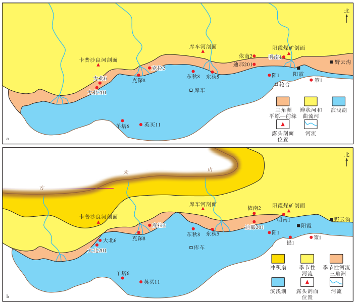

图2
库车坳陷与准噶尔盆地南缘侏罗系—白垩系野外露头特征 a—下侏罗统阿合组厚层灰白色辫状河河道砂体,粗砂岩,库车坳陷阳霞煤矿剖面;b—上侏罗统喀拉扎组薄层砾岩与下白垩统亚格列木组底部厚层砾岩,库车坳陷库车河剖面;c—中侏罗统头屯河组上部曲流河河道冲刷侵蚀泛滥平原泥质粉砂岩,准噶尔盆地南缘头屯河剖面;d—上侏罗统齐古组褐红色泥质粉砂岩与上侏罗统喀拉扎组巨厚砾岩,准噶尔盆地南缘玛纳斯河红沟剖面;e—下白垩统清水河组底部扇三角洲砾岩、砂泥岩与上侏罗统喀拉扎组冲积扇砾岩,准噶尔盆地南缘玛纳斯河红沟剖面;f—下白垩统清水河组扇三角洲前缘砂体,准噶尔盆地南缘玛纳斯河红沟剖面"
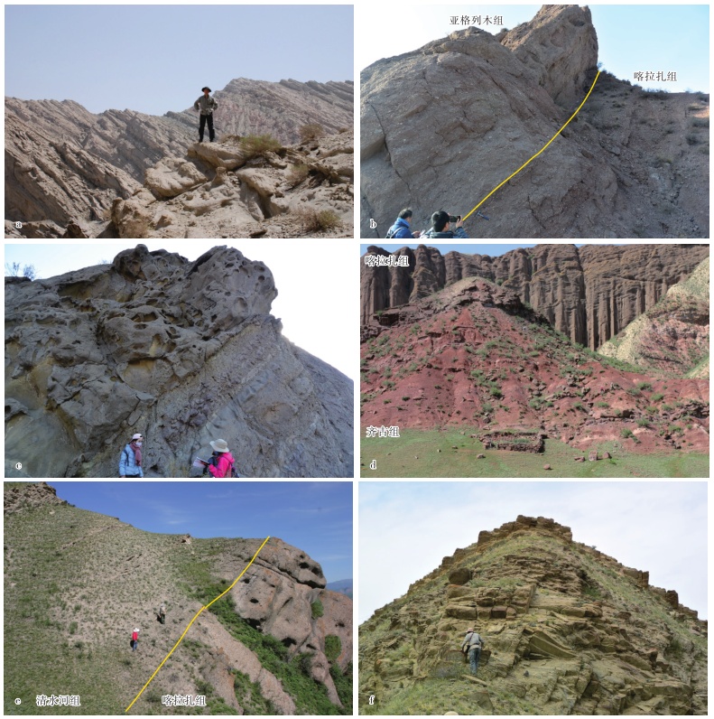
表1
库车坳陷与准噶尔盆地南缘侏罗系—白垩系厚度、岩性组合和沉积特征对比(据文献[4],[7],[17]—[19]修改)"
| 统 | 库车坳陷 | 准噶尔盆地南缘 | ||||||||
|---|---|---|---|---|---|---|---|---|---|---|
| 组 | 厚度/m | 岩性组合 | 沉积相 | 剖面 | 组 | 厚度/m | 岩性组合 | 沉积相 | 剖面 | |
| 上白 垩统 | 东沟组 | 102 | 下部紫红色、棕黄色细—中砾岩,中部灰白色、棕红色砾岩,上部紫色细—中砾岩 | 冲积扇、 辫状河 | 雀儿沟 剖面 | |||||
| 下 白 垩 统 | 巴什基 奇克组 | 224~236 | 上部粉红色厚层块状细—中砂岩夹含砾砂岩,下部紫灰色块状砾岩 | 冲积扇、季节性河流、三角洲 | 库车河剖面、卡普沙良河剖面 | 连木 沁组 | 250~450 | 灰绿色砂岩、粉砂岩与红褐色、紫红色泥岩互层 | 三角洲、 滨浅湖 | 雀儿沟 剖面 |
| 巴西 改组 | 163~490 | 黄灰色、桔红色厚层块状粉—细砂岩、粗砂岩夹泥岩 | 季节性河流、三角洲 | 库车河剖面、阿瓦特河剖面 | 胜金 口组 | 40~80 | 深灰色、灰绿色泥页岩,砂质泥岩夹粉—细砂岩 | 三角洲、 滨浅湖、 半深湖 | 雀儿沟 剖面 | |
| 舒善 河组 | 694~1 099 | 紫红色、灰紫色粉砂质泥岩、粉砂岩夹灰绿色、黄绿色粉砂岩、细砂岩 | 滨浅湖 | 库车河剖面、卡普沙良河剖面 | 呼图壁 河组 | 400~600 | 下部紫红色、绿灰色泥岩、粉—细砂岩与灰色粉砂质泥岩互层,上部紫红色粉砂质泥岩、泥质粉砂岩 | 三角洲平原—前缘、滨浅湖 | 雀儿沟 剖面 | |
| 亚格列 木组 | 60~243 | 浅紫灰色砾岩夹细—中砂岩,灰紫色、灰绿色薄—中层细—中层砂岩、粉砂岩 | 季节性河流、扇三角洲平原 | 库车河剖面、卡普沙良河剖面 | 清水 河组 | 200~400 | 底部灰绿色细—中砾岩,中上部灰绿色、黄绿色泥质粉砂岩与细砂岩互层,夹褐色、紫红色泥质砂岩条带 | 扇三角洲、辫状河 三角洲、 滨浅湖 | 雀儿沟 剖面 | |
| 上 侏 罗 统 | 喀拉 扎组 | 16~63 | 褐红色薄—厚层含钙质砂岩、砾岩夹黄红色、紫红色中—厚层泥质粉砂岩 | 扇三角洲平原— 前缘 | 库车河剖面、卡普沙良河剖面 | 喀拉 扎组 | 65~300 | 橙红色、褐红色中—粗砂岩、砾岩,灰色厚层含砾粗砂岩、细—中砂岩 | 冲积扇、扇三角洲平原、辫状河 | 玛纳斯河红沟剖面、头屯河 剖面 |
| 齐古组 | 272~348 | 红褐色、红色泥岩夹灰白色、灰绿色钙质粉砂岩、泥岩 | 冲积平原、三角洲 平原 | 库车河剖面、卡普沙良河剖面 | 齐古组 | 300 | 暗紫红色、砖红色及褐红色泥岩、粉砂质泥岩夹黄灰色薄—中层砂岩,下部含砾粗砂岩、细—中砂岩 | 冲积平原、曲流河 | 玛纳斯河 红沟剖面 | |
| 中 侏 罗 统 | 恰克 马克组 | 167~278 | 灰绿色、紫色泥岩、砂质泥岩和粉砂岩夹砂岩 | 曲流河—三角洲 平原 | 库车河剖面、阿瓦特河剖面 | 头屯 河组 | 850 | 灰色、浅灰色巨厚层含砾粗砂岩与灰绿色夹紫红色、棕红色条带状泥岩互层 | 辫状河、 曲流河 | 头屯河 剖面 |
| 克孜勒努尔组 | 386~725 | 灰白色、灰绿色细砾岩、含砾砂岩、砂岩与绿灰色、灰黑色粉砂岩、泥页岩及煤 | 曲流河—三角洲平原—前缘 | 吐格尔明剖面、库车河剖面 | 西山 窑组 | 1 100 | 下部灰白色含砾粗砂岩、泥岩夹砂岩透镜体,中部厚层含砾粗砂岩,上部砂岩与泥岩及煤互层 | 辫状河三角洲平原、前缘和 滨浅湖 | 南安集 海河剖面 | |
| 下 侏 罗 统 | 阳霞组 | 531~570 | 上段深灰色、褐灰色厚层泥岩、碳质泥岩,下段灰色细—中砾岩、泥质粉砂岩夹煤层 | 曲流河、三角洲、湖泊 | 库车河剖面、吐格尔明剖面 | 三工 河组 | 860 | 下部黑褐色泥岩夹灰黄色砂岩,中部灰黄色砂岩,上部灰绿色泥质粉砂岩 | 辫状河三角洲平原、前缘和 滨浅湖 | 郝家沟 剖面 |
| 阿合组 | 358~414 | 浅灰色、灰白色厚层块状砾岩、含砾粗砂岩、粗砂岩 | 辫状河 | 库车河剖面、克拉苏河剖面 | 八道 湾组 | 585 | 中—下部厚层浅灰色、灰绿色粗砾岩与泥质粉砂岩互层,上部含砾粗砂岩与煤 | 扇三角洲平原— 前缘 | 石场剖面 | |
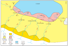
图3
准噶尔盆地南缘中侏罗统头屯河组岩相古地理"


图4
准噶尔盆地南缘上侏罗统喀拉扎组岩相古地理"
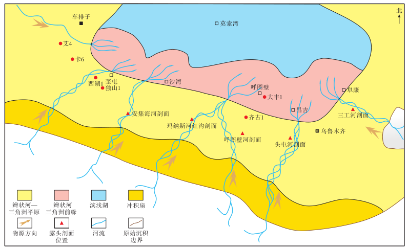
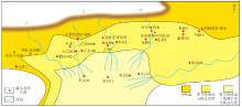
图5
库车坳陷下白垩统巴什基奇克组岩相古地理"
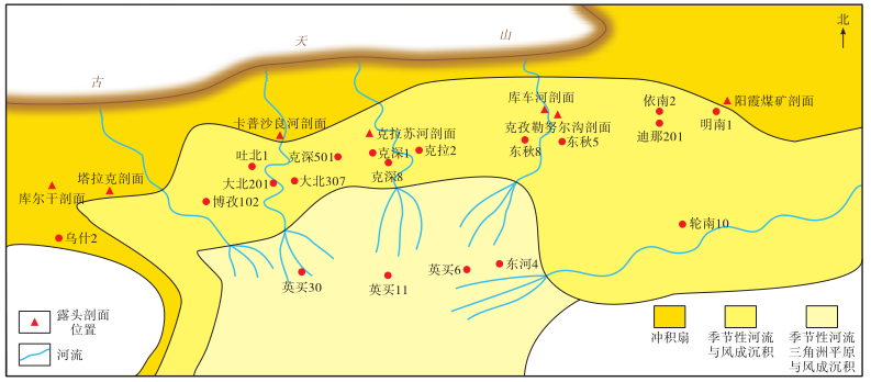

图6
准噶尔盆地南缘中段侏罗系储集层孔隙度随深度的变化"
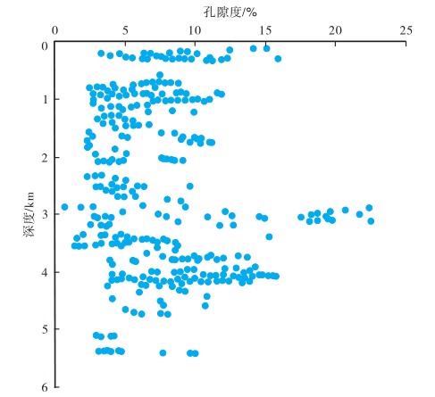

图7
库车坳陷西部白垩系储集层孔隙度(a)与渗透率(b)随深度的变化"
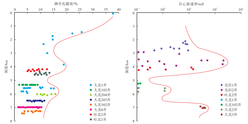

图8
准噶尔盆地南缘安6井地层超压演化模式(据文献[40]修改)"
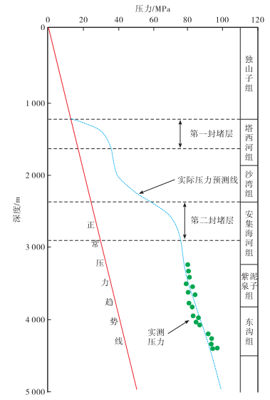
表2
准噶尔盆地南缘侏罗系—白垩系储集层分类评价"
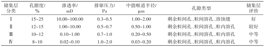 |
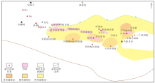
图9
准噶尔盆地南缘上侏罗统喀拉扎组有利储集层分布"

| [1] | 杜金虎, 支东明, 李建忠 , 等. 准噶尔盆地南缘高探1井重大发现及下组合勘探前景展望[J]. 石油勘探与开发, 2019,46(2):205-215. |
| DU Jinhu, ZHI Dongming, LI Jianzhong , et al. Major breakthrough of Well Gaotan 1 and exploration prospects of lower assemblage in southern margin of Junggar basin,NW China[J]. Petroleum Exploration and Development, 2019,46(2):205-215. | |
| [2] | 靳久强, 赵文智, 薛良清 , 等. 中国西北地区侏罗纪原型盆地与演化特征[J]. 地质论评, 1999,45(1):92-104 |
| JIN Jiuqiang, ZHAO Wenzhi, XUE Liangqing , et al. Prototypes and evolution of Jurassic basins in NW China[J]. Geological Review, 1999,45(1):92-104. | |
| [3] | 薛良清, 李文厚, 宋立珩 . 西北地区侏罗纪原始沉积区恢复[J]. 沉积学报, 2000,18(4):539-543. |
| XUE Liangqing, LI Wenhou, SONG Liyan . Reconstruction of original sedimentary province of the Jurassic in the northwestern China[J]. Acta Sedimentologica Sinica, 2000,18(4):539-543. | |
| [4] | 谷云飞, 马明福, 苏世龙 , 等. 准噶尔盆地白垩系岩相古地理[J]. 石油实验地质, 2003,25(4):337-347. |
| GU Yunfei, MA Mingfu, SU Shilong , et al. Lithofacies paleogeography of the Cretaceous in the Junggar basin[J]. Petroleum Geology & Experiment, 2003,25(4):337-347. | |
| [5] | 吴朝东, 全书进, 郭召杰 , 等. 新疆侏罗纪原型盆地类型[J]. 新疆地质, 2004,22(1):56-63. |
| WU Chaodong, QUAN Shujin, GUO Zhaojie , et al. The prototype basins in Xinjiang,western China[J]. Xinjiang Geology, 2004,22(1):56-63. | |
| [6] | 何光玉, 卢华复, 杨树锋 , 等. 库车中新生代盆地沉降特征[J]. 浙江大学学报(理学版), 2004,31(1):110-113. |
| HE Guangyu, LU Huafu, YANG Shufeng , et al. Subsiding features of the Mesozoic and Cenozoic Kuqa basin,northwestern China[J]. Journal of Zhejiang University(Science Edition), 2004,31(1):110-113. | |
| [7] | 高志勇, 周川闽, 冯佳睿 , 等. 中新生代天山隆升及其南北盆地分异与沉积环境演化[J]. 沉积学报, 2016,34(3):415-435. |
| GAO Zhiyong, ZHOU Chuanmin, FENG Jiarui , et al. Relationship between the Tianshan mountains uplift and depositional environment evolution of the basins in Mesozoic-Cenozoic[J]. Acta Sedimentologica Sinica, 2016,34(3):415-435. | |
| [8] | 高志勇, 朱如凯, 冯佳睿 , 等. 中国前陆盆地构造—沉积充填响应与深层储层特征[M]. 北京: 地质出版社, 2016. |
| GAO Zhiyong, ZHU Rukai, FENG Jiarui , et al. The response of depsition within tectonic sequence and characteristics of deep reservoir of foreland basin in China[M]. Beijing: Geological Publishing House, 2016. | |
| [9] | 张荣虎, 曾庆鲁, 李君 , 等. 库车坳陷克拉苏构造带白垩系储集层多期溶蚀物理模拟[J]. 新疆石油地质, 2019,40(1):34-40. |
| ZHANG Ronghu, ZENG Qinglu, LI Jun , et al. Physical simulation of multi-period dissolution in Cretaceous reservoirs of Kelasu tectonic belt,Kuqa depression[J]. Xinjiang Petroleum Geology, 2019,40(1):34-40. | |
| [10] | 伍劲, 王波, 朱超 , 等. 库车坳陷东部下侏罗统煤系地层碎屑岩中长石溶蚀对储集层物性的影响[J]. 新疆石油地质, 2019,40(6):649-657. |
| WU Jin, WANG Bo, ZHU Chao , et al. Influences of feldspar dissolution on reservoir physical properties of clastics in the Lower Jurassic coal measures,eastern Kuqa depression[J]. Xinjiang Petroleum Geology, 2019,40(6):649-657. | |
| [11] | 蒋宜勤, 喻春辉, 常秋生 , 等. 准噶尔盆地北天山山前主要储层特征[J]. 新疆石油地质, 2001,22(2):129-132. |
| JIANG Yiqin, YU Chunhui, CHANG Qiusheng , et al. Reservoir characteristics of principal target strata in northern Tianshan mountain front region of Junggar basin[J]. Xinjiang Petroleum Geology, 2001,22(2):129-132. | |
| [12] | 常秋生 . 影响准噶尔盆地碎屑岩储层储集性的主要因素[J]. 新疆石油学院学报, 2003,15(3):18-20. |
| CHANG Qiusheng . Analysis on dominant factors affecting the reservoir properties of clastic bed in Junggar basin[J]. Journal of Xinjiang Petroleum Institute, 2003,15(3):18-20. | |
| [13] | 雷德文, 唐勇, 常秋生 . 准噶尔盆地南缘深部优质储层及有利勘探领域[J]. 新疆石油地质, 2008,29(4):435-438. |
| LEI Dewen, TANG Yong, CHANG Qiusheng . The deep and relatively high-quality clastic reservoir bodies and favorable exploration areas in southern margin of Junggar basin[J]. Xinjiang Petroleum Geology, 2008,29(4):435-438. | |
| [14] | 况军, 刘得光 . 准噶尔盆地南缘与塔里木盆地库车坳陷天然气成藏条件对比[J]. 新疆石油地质, 2001,22(4):287-290. |
| KUANG Jun, LIU Deguang . Comparative analysis on natural gas reservoir-formed conditions between south margin of Junggar basin and Kuche depression of Tarim basin[J]. Xinjiang Petroleum Geology, 2001,22(4):287-290. | |
| [15] | 管树巍, 陈竹新, 方世虎 . 准噶尔盆地南缘油气勘探的3个潜在领域:来自构造模型的论证[J]. 石油勘探与开发, 2012,39(1):37-44. |
| GUAN Shuwei, CHEN Zhuxin, FANG Shihu . Three potential exploration areas of southern Junggar basin:arguments from structural modeling[J]. Petroleum Exploration and Development, 2012,39(1):37-44. | |
| [16] | 李本亮, 陈竹新, 雷永良 , 等. 天山南缘与北缘前陆冲断带构造地质特征对比及油气勘探建议[J]. 石油学报, 2011,32(3):395-403. |
| LI Benliang, CHEN Zhuxin, LEI Yongliang , et al. Structural geology correlation of foreland thrust-folded belts between the southern and northern edges of the Tianshan mountain and some suggestions for hydrocarbon exploration[J]. Acta Petrolei Sinica, 2011,32(3):395-403. | |
| [17] | 王招明, 钟端, 赵培荣 , 等. 库车前陆盆地露头区油气地质[M]. 北京: 石油工业出版社, 2004. |
| WANG Zhaoming, ZHONG Duan, ZHAO Peirong , et al. Petroleum geology of outcrops areas in Kuche foreland basin[M]. Beijing: Petroleum Industry Press, 2004. | |
| [18] | 况军, 邵雨, 于兴河 , 等. 准噶尔盆地南缘侏罗系地质剖面图集[M]. 北京: 石油工业出版社, 2014. |
| KUANG Jun, SHAO Yu, YU Xinghe , et al. Geological atlas of Jurassic sections in southern Junggar basin[M]. Beijing: Petroleum Industry Press, 2014. | |
| [19] | 杨勇, 陈世悦, 王桂萍 , 等. 准噶尔盆地南缘雀儿沟剖面白垩系地层特征及沉积环境[J]. 油气地质与采收率, 2012,19(3):34-37. |
| YANG Yong, CHEN Shiyue, WANG Guiping , et al. Formation characteristics and sedimentary environment analysis on Cretaceous of Queergou section,Junggar basin[J]. Petroleum Geology and Recovery Efficiency, 2012,19(3):34-37. | |
| [20] | 高志勇, 冯佳睿, 周川闽 , 等. 干旱气候环境下季节性河流沉积特征:以库车河剖面下白垩统为例[J]. 沉积学报, 2014,32(6):1 060-1 071. |
| GAO Zhiyong, FENG Jiarui, ZHOU Chuanmin , et al. Arid climate seasonal rivers deposition:a case of Lower Cretaceous in Kuche river outcrop[J]. Acta Sedimentologica Sinica, 2014,32(6):1 060-1 071. | |
| [21] | 邓胜徽, 卢远征, 樊茹 , 等. 新疆北部的侏罗系[M]. 合肥: 中国科学技术大学出版社, 2010. |
| DENG Shenghui, LU Yuanzheng, FAN Ru , et al. The Jurassic system of northern Xinjiang,China[M]. Hefei: University of Science and Technology of China Press, 2010. | |
| [22] | 邓胜徽, 姚益民, 叶得泉 , 等. 中国北方侏罗系(Ⅰ)地层总述[M]. 北京: 石油工业出版社, 2003. |
| DENG Shenghui, YAO Yimin, YE Dequan , et al. Jurassic system in the north of China(Ⅰ) stratum introduction[M]. Beijing: Petroleum Industry Press, 2003. | |
| [23] | 雷德文, 陈能贵, 李学义 , 等. 准噶尔盆地南缘下部成藏组合储集层及分布特征[J]. 新疆石油地质, 2012,33(6):648-650. |
| LEI Dewen, CHEN Nenggui, LI Xueyi , et al. The major reservoirs and distribution of lower combination in southern margin of Junggar basin[J]. Xinjiang Petroleum Geology, 2012,33(6):648-650. | |
| [24] | 高志勇, 冯佳睿, 安海亭 , 等. 库车前陆盆地白垩系亚格列木组浊流沉积特征与意义[J]. 沉积学报, 2013,31(2):237-247. |
| GAO Zhiyong, FENG Jiarui, AN Haiting , et al. Sedimentary process and reservoir characteristics of turbidite fan of Cretaceous Yageliemu formation in Kuqa foreland basin[J]. Acta Sedimentologica Sinica, 2013,31(2):237-247. | |
| [25] | 李忠, 彭守涛 . 天山南北麓中-新生界碎屑锆石U-Pb年代学记录、物源体系分析与陆内盆山演化[J]. 岩石学报, 2013,29(3):739-755. |
| LI Zhong, PENG Shoutao . U-Pb geochronological records and provenance system analysis of the Mesozoic-Cenozoic sandstone detrital zircons in the northern and southern piedmonts of Tianshan,northwest China:responses to intracontinental basin-range evolution[J]. Acta Petrologica Sinica, 2013,29(3):739-755. | |
| [26] | 江德昕, 王永栋, 魏江 . 新疆乌恰早白垩世孢粉植物群及其环境意义[J]. 古地理学报, 2007,9(2):185-196. |
| JIANG Dexin, WANG Yongdong, WEI Jiang . Palynofloras and their environmental significance of the Early Cretaceous in Wuqia,Xinjiang autonomous region[J]. Journal of Palaeogeography, 2007,9(2):185-196. | |
| [27] | 王长轩 . 新疆车排子地区孢粉植物群与古气候[J]. 微体古生物学报, 2014,31(1):75-84. |
| WANG Changxuan . Spore-pollen flora and paleoclimate of the Chepaizi area,Xinjiang,NW China[J]. Acta Micropalaeontologica Sinica, 2014,31(1):75-84. | |
| [28] | 贾承造, 何登发, 陆洁民 . 中国喜马拉雅运动的期次及其动力学背景[J]. 石油与天然气地质, 2004,25(2):121-125. |
| JIA Chengzao, HE Dengfa, LU Jiemin . Episodes and geodynamic setting of Himalayan movement in China[J]. Oil & Gas Geology, 2004,25(2):121-125. | |
| [29] | 张妮妮, 刘洛夫, 苏天喜 , 等. 库车坳陷东部下侏罗统致密砂岩储层特征及主控因素[J]. 沉积学报, 2015,33(1):160-169. |
| ZHANG Nini, LIU Luofu, SU Tianxi , et al. Reservoir characteristics and main controlling factors of the Lower Jurassic tight sandstone in eastern Kuqa depression[J]. Acta Sedimentologica Sinica, 2015,33(1):160-169. | |
| [30] | 李国欣, 易士威, 林世国 , 等. 塔里木盆地库车坳陷东部地区下侏罗统储层特征及其主控因素[J]. 天然气地球科学, 2018,29(10):1 506-1 517. |
| LI Guoxin, YI Shiwei, LIN Shiguo , et al. Reservoir characteristics and major factors influencing the reservoir quality of Lower Jurassic in eastern Kuqa depression,Tarim basin[J]. Natural Gas Geoscinence, 2018,29(10):1 506-1 517. | |
| [31] | 张健, 李天明, 陈能贵 , 等. 准噶尔盆地南缘西部侏罗—白垩系储层发育特征及分布[J]. 新疆地质, 2012,30(1):62-66. |
| ZHANG Jian, LI Tianming, CHEN Nenggui , et al. The development characteristics and distribution of reservoir in Jurassic and Cretaceous in western part of south margin of Junggar basin[J]. Xinjiang Geology, 2012,30(1):62-66. | |
| [32] | 韩守华, 李娴静, 陈能贵 , 等. 准噶尔盆地南缘中段下组合储层特征及控制因素分析[J]. 沉积与特提斯地质, 2012,32(4):52-58. |
| HAN Shouhua, LI Xianjing, CHEN Nenggui , et al. Hydrocarbon reservoirs and their controlling factors in the lower associations of the middle part of southern Junggar basin,Xinjiang[J]. Sedimentary Geology and Tethyan Geology, 2012,32(4):52-58. | |
| [33] | 杨海军, 李勇, 唐雁刚 , 等. 塔里木盆地克拉苏盐下深层大气田的发现[J]. 新疆石油地质, 2019,40(1):12-20. |
| YANG Haijun, LI Yong, TANG Yan’gang , et al. Discovery of Kelasu subsalt deep large gas field,Tarim basin[J]. Xinjiang Petroleum Geology, 2019,40(1):12-20. | |
| [34] | 王波, 张荣虎, 任康绪 , 等. 库车坳陷大北—克拉苏深层构造带有效储层埋深下限预测[J]. 石油学报, 2011,32(2):212-218. |
| WANG Bo, ZHANG Ronghu, REN Kangxu , et al. Prediction of the lower limit of burial depth for effective reservoirs in the Dabei-Kelasu deep structural belt of Kuqa depression[J]. Acta Petrolei Sinica, 2011,32(2):212-218. | |
| [35] | 寿建峰, 朱国华, 张惠良 . 构造侧向挤压与砂岩成岩压实作用:以塔里木盆地为例[J]. 沉积学报, 2003,21(1):90-95. |
| SHOU Jianfeng, ZHU Guohua, ZHANG Huiliang . Lateral structure compression and its influence on sandstone diagenesis:a case study from the Tarim basin[J]. Acta Sedimentologica Sinica, 2003,21(1):90-95. | |
| [36] | ZENG Lianbo, WANG Hongjun, GONG Lei , et al. Impacts of the tectonic stress field on natural gas migration and accumulation:a case study of the Kuqa depression in the Tarim basin,China[J]. Marine and Petroleum Geology, 2010,27(7):1 616-1 627. |
| [37] | 刘春, 张惠良, 韩波 , 等. 库车坳陷大北地区深部碎屑岩储层特征及控制因素[J]. 天然气地球科学, 2009,20(4):504-512. |
| LIU Chun, ZHANG Huiliang, HAN Bo , et al. Reservoir characteristics and control factors of deep-burial clastic rocks in Dabei zone of Kuche sag[J]. Natural Gas Geoscience, 2009,20(4):504-512. | |
| [38] | 高志勇, 崔京钢, 冯佳睿 , 等. 埋藏压实—构造抬升地质过程下储层孔隙回弹的演化过程模型[J]. 地质科学, 2018,53(2):531-546. |
| GAO Zhiyong, CUI Jinggang, FENG Jiarui , et al. Sandstone pore rebounding evolution model of a geological process from burial compaction to tectonic uplift[J]. Chinese Journal of Geology, 2018,53(2):531-546. | |
| [39] | 王钧, 黄尚瑶, 黄歌山 , 等. 中国地温分布的基本特征[M]. 北京: 地震出版社, 1990. |
| WANG Jun, HUANG Shangyao, HUANG Geshan , et al. The characteristics of geotemperature distribution in China[M]. Beijing: Seismological Press, 1990. | |
| [40] | 张闻林, 张哨楠, 陈义才 , 等. 准南西部地层超压分析[J]. 天然气工业, 2004,24(1):26-28. |
| ZHANG Wenlin, ZHANG Shaonan, CHEN Yicai , et al. Analysis of formation overpressures in the west area of Zhunnan region[J]. Natural Gas Industry, 2004,24(1):26-28. | |
| [41] | 吴海生, 郑孟林, 何文军 , 等. 准噶尔盆地腹部地层压力异常特征与控制因素[J]. 石油与天然气地质, 2017,38(6):1 135-1 146. |
| WU Haisheng, ZHENG Menglin, HE Wenjun , et al. Formation pressure anomalies and controlling factors in central Junggar basin[J]. Oil & Gas Geology, 2017,38(6):1 135-1 146. | |
| [42] | 李铁军 . 准噶尔盆地南缘异常高压及其成因机制初探[J]. 地质科学, 2004,39(2):234-244. |
| LI Tiejun . Overpressure and its generation in south margin of the Junggar basin[J]. Chinese Journal of Geology, 2004,39(2):234-244. | |
| [43] | 万敏 . 准南缘及车排子地区深部碎屑岩优质储层控制因素分析[J]. 新疆石油天然气, 2009,5(2):8-10. |
| WAN Min . Analysis of deep clastic rock reservoir quality controlling factors in southern Junggar and Chepaizi region[J]. Xinjiang Oil & Gas, 2009,5(2):8-10. |
| [1] | 阿力甫江·热合木吐力, 潘龙, 李献民, 林娟, 马晶晶, 窦强峰. 基于双平方根算子的速度建模方法及应用[J]. 新疆石油地质, 2023, 44(1): 119-124. |
| [2] | 况昊, 周润驰, 王钧民, 刘豪, 谭先锋, 蔡鑫勇, 肖振兴. 玛湖凹陷与沙湾凹陷上乌尔禾组储集层差异及成因[J]. 新疆石油地质, 2023, 44(1): 18-24. |
| [3] | 何海清, 唐勇, 邹志文, 郭华军, 徐洋, 李亚哲. 准噶尔盆地中央坳陷西部风城组岩相古地理及油气勘探[J]. 新疆石油地质, 2022, 43(6): 640-653. |
| [4] | 唐勇, 雷德文, 曹剑, 刘寅, 黄立良, 李卉. 准噶尔盆地二叠系全油气系统与源内天然气勘探新领域[J]. 新疆石油地质, 2022, 43(6): 654-662. |
| [5] | 何文军, 宋永, 汤诗棋, 尤新才, 白雨, 赵毅. 玛湖凹陷二叠系风城组全油气系统成藏机理[J]. 新疆石油地质, 2022, 43(6): 663-673. |
| [6] | 龚德瑜, 刘海磊, 杨海波, 李宗浩, 王瑞菊, 吴卫安. 准噶尔盆地风城组烃源岩生气潜力与天然气勘探领域[J]. 新疆石油地质, 2022, 43(6): 674-683. |
| [7] | 蒋文龙, 阿布力米提·依明, 卞保力, 王韬, 任海姣, 韩杨. 准噶尔盆地西北缘风城组烃源岩热演化生物标志化合物变化及意义[J]. 新疆石油地质, 2022, 43(6): 684-692. |
| [8] | 钱门辉, 王绪龙, 黎茂稳, 李志明, 冷筠莹, 孙中良. 玛页1井风城组页岩含油性与烃类赋存状态[J]. 新疆石油地质, 2022, 43(6): 693-703. |
| [9] | 单祥, 窦洋, 晏奇, 陈希光, 彭博, 易俊峰. 玛南斜坡区风城组致密油藏储集层特征及控制因素[J]. 新疆石油地质, 2022, 43(6): 704-713. |
| [10] | 雷海艳, 齐婧, 周妮, 陈俊, 孟颖, 张锡新, 陈锐兵. 玛湖凹陷玛页1井风城组富硅页岩成因及其油气意义[J]. 新疆石油地质, 2022, 43(6): 724-732. |
| [11] | 刘财广, 季瑞雪, 王伟, 张融. 玛湖凹陷风城组页岩油产量影响因素及甜点评价[J]. 新疆石油地质, 2022, 43(6): 733-742. |
| [12] | 吕焕泽, 邹妞妞, 蔡宁宁, 黄永志, 宁诗坦, 朱彪. 玛湖凹陷北斜坡百口泉组碳酸盐胶结物形成机理及其地质意义[J]. 新疆石油地质, 2022, 43(5): 554-562. |
| [13] | 王亚如, 张昌民, 冀冬升, 朱锐, 付文俊, 王泽宇, 刘家乐. 齐古断褶带头屯河组—清水河组地球化学特征及古环境[J]. 新疆石油地质, 2022, 43(5): 563-571. |
| [14] | 王泉, 王彬, 闫利恒, 汪洋, 罗建新, 杜果. 呼探1井井口压力波动特征及成因机理[J]. 新疆石油地质, 2022, 43(5): 587-591. |
| [15] | 魏军, 严宝年, 杜文博, 周晓峰, 周在华, 李铁锋, 谢菁钰. 酒泉盆地长沙岭构造带下沟组一段油藏圈闭特征及形成机理[J]. 新疆石油地质, 2022, 43(4): 379-386. |
| 阅读次数 | ||||||
|
全文 |
|
|||||
|
摘要 |
|
|||||