
新疆石油地质 ›› 2023, Vol. 44 ›› Issue (6): 646-656.doi: 10.7657/XJPG20230602
张长建( ), 杨德彬, 吕艳萍, 张娟, 李杰, 丁立明
收稿日期:2023-03-01
修回日期:2023-08-03
出版日期:2023-12-01
发布日期:2023-11-29
作者简介:张长建(1983-),男,江西萍乡人,副研究员,硕士,油气地质,(Tel)18999830628(Email)基金资助:
ZHANG Changjian(), YANG Debin, LYU Yanping, ZHANG Juan, LI Jie, DING Liming
Received:2023-03-01
Revised:2023-08-03
Online:2023-12-01
Published:2023-11-29
摘要:
塔里木盆地塔河油田中—下奥陶统海西运动早期地表及地下岩溶形态多样,地下岩溶缝洞系统中油气资源丰富。根据高精度地震资料及钻井资料,统一地下及地表水系统,构建了塔河油田中—下奥陶统海西运动早期岩溶水系统。研究结果表明:塔河油田中—下奥陶统在海西运动早期发育4个岩溶台地,总体呈东高西低阶梯分布,岩溶水差异化排泄和溶蚀作用造成各岩溶台地发育峡谷、伏流、深切曲流、宽谷等不同水文地貌形态;岩溶水系统的边界主要为地表分水岭、排泄基准面、地层岩性组合、断裂和弱溶蚀带;塔河油田岩溶水系统划分为4个相对独立的二级岩溶水系统,分别为高原峡谷水系统、伏流峡谷水系统、深切曲流水系统和宽谷水系统;岩溶水系统层级结构的划分为深化塔河油田岩溶缝洞系统和岩溶缝洞单元认识提供地质依据。
中图分类号:
张长建, 杨德彬, 吕艳萍, 张娟, 李杰, 丁立明. 塔河油田海西运动早期岩溶水系统划分及特征[J]. 新疆石油地质, 2023, 44(6): 646-656.
ZHANG Changjian, YANG Debin, LYU Yanping, ZHANG Juan, LI Jie, DING Liming. Division and Characteristics of Karst Water System in Early Hercynian Movement in Tahe Oilfield, Tarim Basin[J]. Xinjiang Petroleum Geology, 2023, 44(6): 646-656.
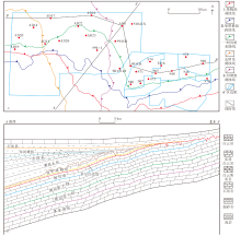
图1
塔河油田构造位置(a)和地质剖面(b)"

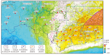
图2
塔河油田海西运动早期岩溶古地貌"

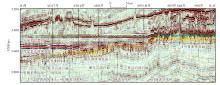
图3
塔河油田沿石炭系顶构造趋势面拉平之后东西向地震剖面(剖面位置见图1a)"

表1
塔河油田海西运动早期岩溶水文地貌分类"
| 岩溶台地 (岩溶水系统) | 古地貌高程/m | 微地貌 | 地表水系 | 地下水系 |
|---|---|---|---|---|
| Ⅰ号岩溶台地 (高原峡谷水系统) | -300~-100 | 峡谷、峰丛、丘丛和沟谷 | 南北向汇流,对称型树枝状地表水系 | 平面树枝状结构,少量单支状和网状,洞道延伸长度长,个别长达20.0 km,主要为暗河型 |
| Ⅱ号岩溶台地 (伏流峡谷水系统) | -350~-300 | 峡谷、溶峰、溶丘和洼地 | 南北向汇流,向斜式树枝状地表水系,主干水系呈深切曲流峡谷、峡谷和伏流-天窗3段结构 | 平面树枝状结构,洞道延伸长度长达8.0 km,主要为伏流型和暗河型 |
| Ⅲ号岩溶台地 (深切曲流水系统) | -500~-350 | 曲流峡谷、溶峰、溶丘和洼地 | 东西向汇流,南北向汇流模式的深切曲流地表水系;S94-1地表水系为由北向南的扇形汇流模式 | 平面单支状结构,少量树枝状,延伸长度较短,为0.4~4.0 km,主要为顺河潜流型、伏流型、暗河型、渗流入流型和穿洞型 |
| Ⅳ号岩溶台地 (宽谷水系统) | -600~-500 | 溶丘、洼地和平原 | 由北向南汇流,树枝状宽谷地表水系 | 平面单支状结构,洞道延伸长度为0.2~0.4 km,主要为暗河型 |
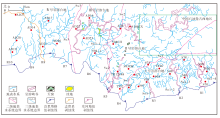
图4
塔河油田海西运动早期岩溶地表水系统"

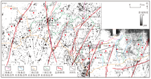
图5
塔河油田海西运动早期岩溶水系统边界"

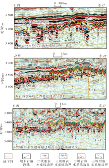
图6
塔河油田海西运动早期地表分水岭与岩溶水系统边界分异剖面(剖面位置见图5)"
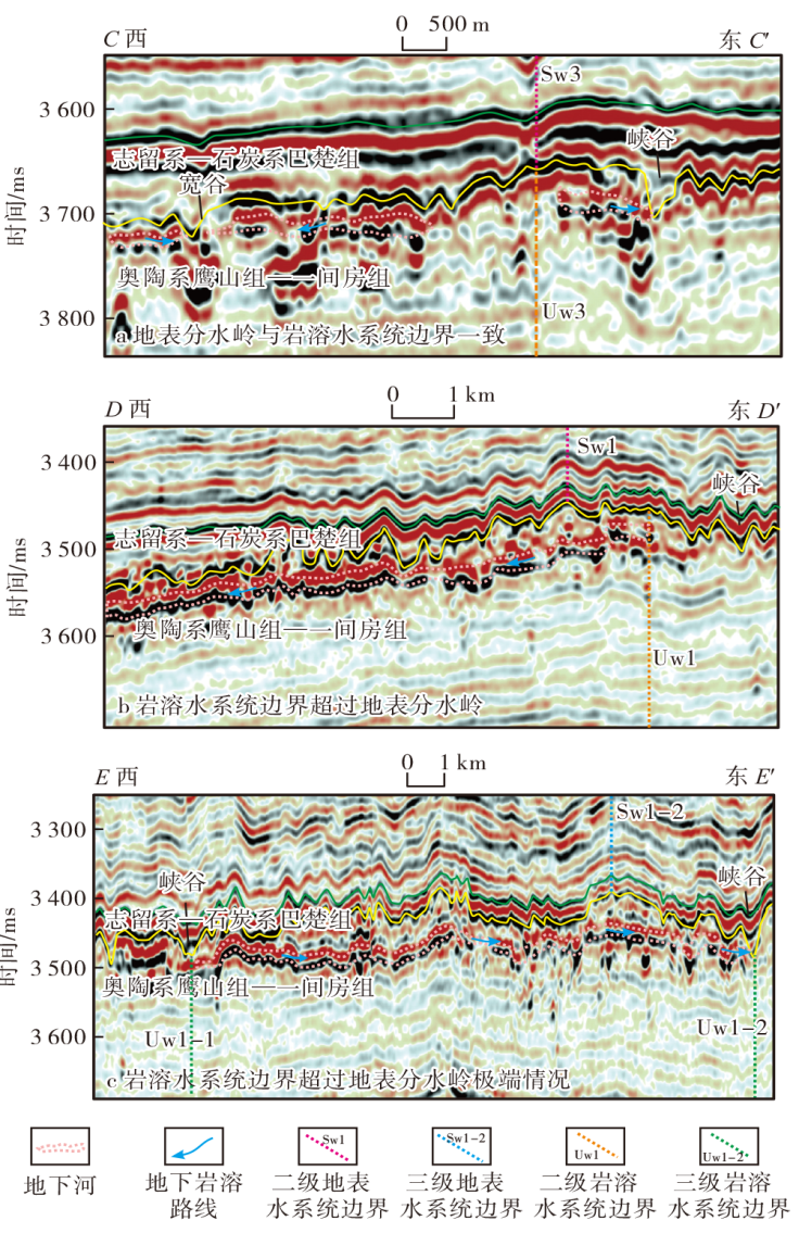
图7
塔河油田海西运动早期岩溶水系统分布"
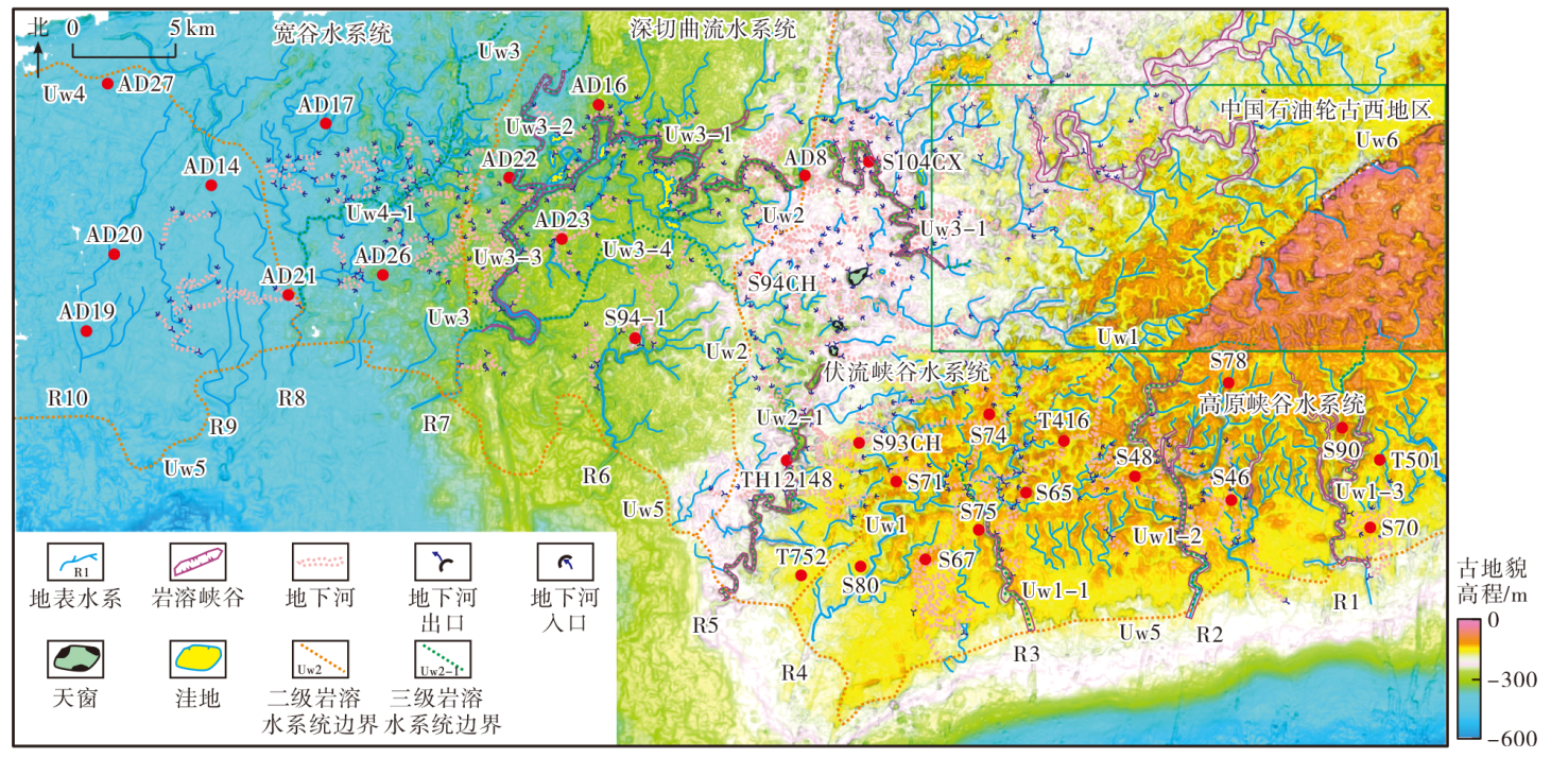
图8
塔河油田裸露区海西早期古岩溶洞穴发育模式(剖面位置见图1a)"

| [1] | 韩行瑞, 时坚, 唐建生, 等. 北方岩溶地下水系统的研究方法:以三姑泉域为例[J]. 中国岩溶, 1990, 9(3):197-210. |
| HAN Xingrui, SHI Jian, TANG Jiansheng, et al. Method of study on kasrt groundwater systems in north China:Case history of Sangu Spring basin[J]. Carsologica Sinica, 1990, 9(3):197-210. | |
| [2] | 梁永平, 王维泰. 中国北方岩溶水系统划分与系统特征[J]. 地球学报, 2010, 31(6):860-868. |
| LIANG Yongping, WANG Weitai. The division and characteristics of karst water systems in northern China[J]. Acta Geoscientica Sinica, 2010, 31(6):860-868. | |
| [3] | 韩行瑞, 鲁荣安, 李庆松. 岩溶水系统:山西岩溶大泉研究[M]. 北京: 地质出版社, 1993. |
| HAN Xingrui, LU Rong’an, LI Qingsong. Karst water system:A study on big karst springs in Shanxi[M]. Beijing: Geological Publishing House, 1993. | |
| [4] | 梁永平, 韩行瑞, 时坚, 等. 鄂尔多斯盆地周边岩溶地下水系统模式及特点[J]. 地球学报, 2005, 26(4):365-369. |
| LIANG Yongping, HAN Xingrui, SHI Jian, et al. The karst groundwater system in the peripheral area of Ordos basin:Its patterns and characteristics[J]. Acta Geoscientica Sinica, 2005, 26(4):365-369. | |
| [5] | 冯亚伟, 陈洪年, 贾德旺. 山东省岩溶地下水系统划分及构造模式[J]. 水文, 2020, 40(6):83-88. |
| FENG Yawei, CHEN Hongnian, JIA Dewang. Division and structural pattern of karst groundwater system in Shandong province[J]. Journal of China Hydrology, 2020, 40(6):83-88. | |
| [6] | 王波, 张华, 王宇, 等. 泸西喀斯特断陷盆地地表水与地下水流域边界与水动力性质[J]. 中国岩溶, 2020, 39(3):319-326. |
| WANG Bo, ZHANG Hua, WANG Yu, et al. Watershed boundaries and hydrodynamic properties of surface water and groundwater in the Luxi karst fault-depression basin[J]. Carsologica Sinica, 2020, 39(3):319-326. | |
| [7] |
李阳, 金强, 钟建华, 等. 塔河油田奥陶系岩溶分带及缝洞结构特征[J]. 石油学报, 2016, 37(3):289-298.
doi: 10.7623/syxb201603001 |
|
LI Yang, JIN Qiang, ZHONG Jianhua, et al. Karst zonings and fracture-cave structure characteristics of Ordovician reservoirs in Tahe oilfield,Tarim basin[J]. Acta Petrolei Sinica, 2016, 37 (3):289-298.
doi: 10.7623/syxb201603001 |
|
| [8] | 鲁新便, 蔡忠贤. 缝洞型碳酸盐岩油藏古溶洞系统与油气开发:以塔河碳酸盐岩溶洞型油藏为例[J]. 石油与天然气地质, 2010, 31(1):22-27. |
| LU Xinbian, CAI Zhongxian. A study of the paleo-cavern system in fractured-vuggy carbonate reservoirs and oil/gas development: Taking the reservoirs in Tahe oilfield as an example[J]. Oil & Gas Geology, 2010, 31(1):22-27. | |
| [9] | 鲁新便, 何成江, 邓光校, 等. 塔河油田奥陶系油藏喀斯特古河道发育特征描述[J]. 石油实验地质, 2014, 36(3):268-274. |
| LU Xinbian, HE Chengjiang, DENG Guangxiao, et al. Development features of karst ancient river system in Ordovician reservoirs,Tahe oil field[J]. Petroleum Geology & Experiment, 2014, 36(3):268-274. | |
| [10] | 鲁新便, 杨敏, 汪彦, 等. 塔里木盆地北部“层控”与“断控”型油藏特征:以塔河油田奥陶系油藏为例[J]. 石油实验地质, 2018, 40(4):461-469. |
| LU Xinbian, YANG Min, WANG Yan, et al. Geological characteristics of “strata-bound” and “fault-controlled” reservoirs in the northern Tarim basin:Taking the Ordovician reservoir in the Tahe oil field as an example[J]. Petroleum Geology & Experiment, 2018, 40(4):461-469. | |
| [11] | 吕艳萍, 吕晶, 徐想东, 等. 塔里木盆地塔河油田中下奥陶统鹰山组内幕储层成因机理[J]. 石油实验地质, 2021, 43(6):1031-1037. |
| LÜ Yanping, LÜ Jing, XU Xiangdong, et al. Genetic mechanism of inner reservoirs of Yingshan formation of Middle-Lower Ordovician in Tahe oil field,Tarim basin[J]. Petroleum Geology & Experiment, 2021, 43(6):1031-1037. | |
| [12] |
李源, 鲁新便, 蔡忠贤, 等. 塔河油田海西早期古水文地貌特征及其对洞穴发育的控制[J]. 石油学报, 2016, 37(8):1011-1020.
doi: 10.7623/syxb201608007 |
|
LI Yuan, LU Xinbian, CAI Zhongxian, et al. Hydrogeomorphologic characteristics and its controlling caves in Hercynian, Tahe oilfield[J]. Acta Petrolei Sinica, 2016, 37(8):1011-1020.
doi: 10.7623/syxb201608007 |
|
| [13] | 李源, 鲁新便, 蔡忠贤, 等. 塔里木盆地塔河油田岩溶峡谷区海西早期洞穴系统发育模式[J]. 古地理学报, 2017, 19(2):364-372. |
| LI Yuan, LU Xinbian, CAI Zhongxian, et al. Development model of Hercynian cave system in karst canyon area of Tahe oilfield,Tarim basin[J]. Journal of Palaeogeography, 2017, 19(2):364-372. | |
| [14] |
蔡忠贤, 张恒, 漆立新, 等. 塔里木盆地中—下奥陶统岩溶水文地貌结构类型及特征[J]. 石油学报, 2020, 41(1):43-58.
doi: 10.7623/syxb202001004 |
|
CAI Zhongxian, ZHANG Heng, QI Lixin, et al. Types and characteristics of karst hydrogeomorphologic architecture in the Middle-Lower Ordovician,Tarim basin[J]. Acta Petrolei Sinica, 2020, 41(1):43-58.
doi: 10.7623/syxb202001004 |
|
| [15] | 金强, 田飞. 塔河油田岩溶型碳酸盐岩缝洞结构研究[J]. 中国石油大学学报(自然科学版), 2013, 37(5):15-21. |
| JIN Qiang, TIAN Fei. Investigation of fracture-cave constructions of karsted carbonate reservoirs of Ordovician in Tahe oilfield,Tarim basin[J]. Journal of China University of Petroleum(Edition of Natural Science), 2013, 37(5):15-21. | |
| [16] | 吕艳萍, 姜应兵, 高济元, 等. 塔河西部奥陶系古岩溶小流域的划分及其地质意义[J]. 断块油气田, 2021, 28(4):440-445. |
| LYU Yanping, JIANG Yingbing, GAO Jiyuan, et al. The division of the Ordovician paleokarst small watershed in the west of Tahe and its geological significance[J]. Fault-Block Oil & Gas Field, 2021, 28(4):440-445. | |
| [17] | 张娟, 鲍典, 杨敏, 等. 塔河油田西部古暗河缝洞结构特征及控制因素[J]. 油气地质与采收率, 2018, 25(4):33-39. |
| ZHANG Juan, BAO Dian, YANG Min, et al. Analysis on fracture-cave structure characteristics and its controlling factor of palaeo-subterranean rivers in the western Tahe oilfield[J]. Petroleum Geology and Recovery Efficiency, 2018, 25(4):33-39. | |
| [18] | 张庆玉, 梁彬, 曹建文, 等. 塔里木盆地轮古东地区前石炭纪古岩溶微地貌及岩溶发育模式[J]. 海相油气地质, 2017, 22(3):30-36. |
| ZHANG Qingyu, LIANG Bin, CAO Jianwen, et al. Micro-paleogeo-morphology and karst development model of the Pre-Carboniferous in eastern Lungu area,Tarim basin[J]. Marine Origin Petroleum Geology, 2017, 22(3):30-36. | |
| [19] | 张庆玉, 梁彬, 曹建文, 等. 塔里木盆地轮古西地区奥陶系古潜山岩溶作用机理与发育模式[J]. 石油实验地质, 2015, 37(1):1-7. |
| ZHANG Qingyu, LIANG Bin, CAO Jianwen, et al. Mechanism and development model of karsts in Ordovician buried hills in western Lungu area,Tarim basin[J]. Petroleum Geology & Experiment, 2015, 37(1):1-7. | |
| [20] | 韩杰, 刘俊锋, 吴江勇, 等. 轮古油田奥陶系潜山地下河发育特征及其与油气的关系[J]. 海相油气地质, 2018, 23(3):1-10. |
| HAN Jie, LIU Junfeng, WU Jiangyong, et al. Development characteristics of underground river in Ordovician buried-hill and the distribution of oil and gas in Lungu oilfield,Tarim basin[J]. Marine Origin Petroleum Geology, 2018, 23(3):1-10. | |
| [21] | 曹建文. 轮南古潜山东部地区古岩溶分布规律及成因机理研究[D]. 武汉: 中国地质大学(武汉), 2019. |
| CAO Jianwen. Distribution law and genesis mechanism of paleokarst in the eastern part of Lunnan paleoburied mountain[D]. Wuhan: China University of Geosciences(Wuhan), 2019. | |
| [22] | 王宇. 岩溶区地表水与地下水资源及环境统一评价的流域边界划分研究[J]. 中国岩溶, 2019, 38(6):823-830. |
| WANG Yu. Study on watershed boundary division for unified evaluation of surface water and groundwater resources and environment in karst areas[J]. Carsologica Sinica, 2019, 38(6):823-830. | |
| [23] | 胡文革. 塔里木盆地塔河油田潜山区古岩溶缝洞类型及其改造作用[J]. 石油与天然气地质, 2022, 43(1):43-53. |
| HU Wenge. Paleokarst fracture-vug types and their reconstruction in buried hill area,Tahe oilfield,Tarim basin[J]. Oil & Gas Geology, 2022, 43(1):43-53. | |
| [24] | 张长建, 吕艳萍, 文欢, 等. 塔河油田西部斜坡区加里东运动中期Ⅱ幕水文地貌特征及其对洞穴发育的控制[J]. 新疆石油地质, 2022, 43(2):135-144. |
| ZHANG Changjian, LYU Yanping, WEN Huan, et al. Paleo-hydrogeomorphic characteristics of episode Ⅱ of Middle Caledonian movement and their controls on karst cave development in western slope area of Tahe oilfield[J]. Xinjiang Petroleum Geology, 2022, 43(2):135-144. | |
| [25] |
耿甜, 吕艳萍, 巫波, 等. 缝洞型油藏储量评价方法及开发对策[J]. 特种油气藏, 2021, 28(6):129-136.
doi: 10.3969/j.issn.1006-6535.2021.06.017 |
| GENG Tian, LV Yanping, WU Bo, et al. Reservoir evaluation method and development countermeasures for fracture-vuggy reservoir[J]. Special Oil & Gas Reservoirs, 2021, 28(6):129-136. | |
| [26] | 漆立新, 云露. 塔河油田奥陶系碳酸盐岩岩溶发育特征与主控因素[J]. 石油与天然气地质, 2010, 31(1):1-12. |
| QI Lixin, YUN Lu. Development characteristics and main controlling factors of the Ordovician carbonate karst in Tahe oilfield[J]. Oil & Gas Geology, 2010, 31(1):1-12. | |
| [27] | 赵永强, 云露, 王斌, 等. 塔里木盆地塔河油田中西部奥陶系油气成藏主控因素与动态成藏过程[J]. 石油实验地质, 2021, 43(5):758-766. |
| ZHAO Yongqiang, YUN Lu, WANG Bin, et al. Main constrains and dynamic process of Ordovician hydrocarbon accumulation,central and western Tahe oil field,Tarim basin[J]. Petroleum Geology & Experiment, 2021, 43(5):758-766. | |
| [28] | 周文, 李秀华, 金文辉, 等. 塔河奥陶系油藏断裂对古岩溶的控制作用[J]. 岩石学报, 2011, 27(8):2339-2348. |
| ZHOU Wen, LI Xiuhua, JIN Wenhui, et al. The control action of fault to paleokarst in view of Ordovician reservoir in Tahe area[J]. Acta Petrologica Sinica, 2011, 27(8):2339-2348. | |
| [29] | 李源, 蔡忠贤, 张恒, 等. 塔河油田T738井区顺层岩溶储层特征及成因[J]. 地质科技情报, 2017, 36(2):80-85. |
| LI Yuan, CAI Zhongxian, ZHANG Heng, et al. Characteristics and genesis of bedded karstification in T738 region of Tahe oilfield[J]. Geological Science and Technology Information, 2017, 36(2):80-85. | |
| [30] | 张三, 金强, 赵深圳, 等. 塔河油田海西运动早期奥陶系岩溶地貌[J]. 新疆石油地质, 2020, 41(5):527-534. |
| ZHANG San, JIN Qiang, ZHAO Shenzhen, et al. Ordovician karst paleogeomorphology during Early Hercynian movement in Tahe oilfield[J]. Xinjiang Petroleum Geology, 2020, 41(5):527-534. | |
| [31] | 邓兴梁, 张庆玉, 梁彬, 等. 塔中Ⅱ区奥陶系鹰山组岩溶古地貌恢复方法研究[J]. 中国岩溶, 2015, 34(2):154-158. |
| DENG Xingliang, ZHANG Qingyu, LIANG Bin, et al. Reconstruction of karst palaeogeomorphology for the Ordovician Yingshan formation in the central Tarim basin[J]. Carsologica Sinica, 2015, 34(2):154-158. | |
| [32] | 任美锷. 岩溶学概论[M]. 北京: 商务印书馆, 1983. |
| REN Mei’e. Karst introduction[M]. Beijing: The Commercial Press, 1983. | |
| [33] | 张长建, 吕艳萍, 马海陇, 等. 塔河油田岩溶峡谷区伏流坍塌型古暗河缝洞系统[J]. 新疆石油地质, 2023, 44(1):9-17. |
| ZHANG Changjian, LYU Yanping, MA Hailong, et al. Fracture-cave system in collapsed underground paleo-river with subterranean flow in karst canyon area,Tahe oilfield[J]. Xinjiang Petroleum Geology, 2023, 44(1):9-17. | |
| [34] | 张长建, 吕艳萍, 张振哲. 塔里木盆地塔河油田西部斜坡区中下奥陶统古岩溶洞穴发育特征[J]. 石油实验地质, 2022, 44(6):1008-1017. |
| ZHANG Changjian, LÜ Yanping, ZHANG Zhenzhe. Features of Middle-Lower Ordovician paleo-karst caves in western slope area,Tahe oil field,Tarim basin[J]. Petroleum Geology & Experiment, 2022, 44(6):1008-1017. | |
| [35] | 吕海涛, 张哨楠, 马庆佑. 塔里木盆地中北部断裂体系划分及形成机制探讨[J]. 石油实验地质, 2017, 39(4):444-452. |
| LÜ Haitao, ZHANG Shaonan, MA Qingyou. Classification and formation mechanism of fault systems in the central and northern Tarim basin[J]. Petroleum Geology & Experiment, 2017, 39(4):444-452. | |
| [36] | 姜应兵, 李兴娟. 塔里木盆地塔河油田TH12402井区中下奥陶统古岩溶洞穴发育模式[J]. 古地理学报, 2021, 23(4):824-836. |
| JIANG Yingbing, LI Xingjuan. Development model of paleokarst caves in the Middle-Lower Ordovician of TH12402 well area in Tahe oilfield,Tarim basin[J]. Journal of Palaeogeography, 2021, 23(4):824-836. | |
| [37] | 何宇彬. 试论喀斯特水动力剖面模式[J]. 地球科学:中国地质大学学报, 1994, 19(1):119-127. |
| HE Yubin. Comment on karst hydrodynamical section[J]. Earth Science:Journal of China University of Geosciences, 1994, 19(1):119-127. | |
| [38] | 蔡忠贤, 刘永立, 段金宝. 岩溶流域的水系变迁:以塔河油田6区西北部奥陶系古岩溶为例[J]. 中国岩溶, 2009, 28(1):30-34. |
| CAI Zhongxian, LIU Yongli, DUAN Jinbao. Transition of river system in karst basin:A case study on Ordovician palaeo-karst in the northwest of Block 6,Tahe oilfield[J]. Carsologica Sinica, 2009, 28(1):30-34. | |
| [39] | 邹豹君. 小地貌学原理[M]. 北京: 商务印书馆, 1985. |
| ZOU Baojun. Principles of small geomorphology[M]. Beijing: The Commercial Press, 1985. |
| [1] | 李冬梅. 顺北油气田含水高含凝析油凝析气井产能评价[J]. 新疆石油地质, 2023, 44(6): 696-701. |
| [2] | 李小波, 魏学刚, 刘学利, 张艺晓, 李青. 顺北油田超深断控缝洞型油藏注水开发实践[J]. 新疆石油地质, 2023, 44(6): 702-710. |
| [3] | 汪如军, 王培俊, 牛阁, 王怀龙, 张洁, 梁芮晗, 赵欣玥. 深大断裂控制油藏油柱高度计算方法[J]. 新疆石油地质, 2023, 44(5): 608-612. |
| [4] | 程洪. 不同成因岩溶储集体氮气辅助重力驱实验[J]. 新疆石油地质, 2023, 44(5): 613-617. |
| [5] | 段永贤, 宋金鹏, 郇志鹏, 杨连刚, 周鹏, 吕端川, 田志宏. 塔北、塔中奥陶系碳酸盐岩异常高压形成、保存与分布[J]. 新疆石油地质, 2023, 44(4): 421-428. |
| [6] | 胡文革, 李小波, 杨敏, 鲁新便, 刘学利, 刘洪光. 塔河油田碳酸盐岩缝洞型油藏井网优化[J]. 新疆石油地质, 2023, 44(4): 429-434. |
| [7] | 刘丽娜, 曹飞, 刘学利, 谭涛, 郑小杰, 刘蕊. 塔河油田块状底水砂岩油藏开发特征及挖潜对策[J]. 新疆石油地质, 2023, 44(4): 450-455. |
| [8] | 李海英, 韩俊, 陈平, 李媛, 卜旭强. 塔里木盆地顺北4号走滑断裂带变形特征及有利区评价[J]. 新疆石油地质, 2023, 44(2): 127-135. |
| [9] | 刘学利, 谭涛, 陈勇, 解慧, 朱苏阳, 吴昊镪, 向东流. 顺北一区断溶体油藏溶解气驱开发特征[J]. 新疆石油地质, 2023, 44(2): 195-202. |
| [10] | 巫波, 杨文东, 吕晶, 罗君兰. 塔河油田缝洞型储集层类型综合识别[J]. 新疆石油地质, 2023, 44(2): 238-244. |
| [11] | 仲米虹, 唐武. 塔北地区三叠纪拗陷湖盆异重流沉积特征及主控因素[J]. 新疆石油地质, 2023, 44(1): 1-8. |
| [12] | 唐军, 何泽, 申威, 齐戈为, 郭为民. 对标产能的碳酸盐岩储集层测井分类评价——以塔里木盆地托甫台地区一间房组为例[J]. 新疆石油地质, 2023, 44(1): 112-118. |
| [13] | 陈平, 能源, 吴鲜, 黄诚, 王来源, 郭曼. 塔里木盆地顺北5号走滑断裂带分层分段特征及构造演化[J]. 新疆石油地质, 2023, 44(1): 33-42. |
| [14] | 代兰, 邬光辉, 陈鑫, 朱永峰, 陈思锜, 罗鑫, 胡明. 共轭走滑断裂形成演化的控制因素及物理模拟实验[J]. 新疆石油地质, 2023, 44(1): 43-50. |
| [15] | 顾浩, 康志江, 尚根华, 张冬丽, 李红凯, 黄孝特. 超深层断控缝洞型油藏油井合理产能优化方法及应用[J]. 新疆石油地质, 2023, 44(1): 64-69. |
| 阅读次数 | ||||||
|
全文 |
|
|||||
|
摘要 |
|
|||||