
新疆石油地质 ›› 2026, Vol. 47 ›› Issue (1): 92-102.doi: 10.7657/XJPG20260110
芦慧( ), 汪飞, 张译丹, 汪俊伟, 张金龙, 陈磊, 肖贝, 杨皝, 李臣
收稿日期:2025-07-21
出版日期:2026-02-01
发布日期:2026-01-23
作者简介:芦慧(1989-),女,新疆昌吉人,高级工程师,硕士,资源战略规划,(Email)基金资助:
LU Hui(), WANG Fei, ZHANG Yidan, WANG Junwei, ZHANG Jinlong, CHEN Lei, XIAO Bei, YANG Huang, LI Chen
Received:2025-07-21
Online:2026-02-01
Published:2026-01-23
摘要:
地热资源作为清洁稳定的非碳基能源,对中国实现“双碳”目标具有重要意义,准噶尔盆地的地热研究较为薄弱。以准噶尔盆地西部隆起为研究区,开展现今地温场分布与地热资源评价,利用11口井的高质量连续测温数据,分析了地温梯度与大地热流分布特征,并利用一维稳态热传导方程,揭示了5 000 m以浅地层温度的平面分布规律,在此基础上,评价了石炭系及以上7套热储的地热资源量。结果表明:西部隆起平均地温梯度为(21.3±3.0)℃/km,平均大地热流为(43.9±6.9)mW/m2;中拐凸起为相对高热异常区,平均地温梯度为(23.3±2.8)℃/km,平均大地热流为(47.9±5.8)mW/m2;西部隆起埋深4 000 m处地层温度为78.0~122.9 ℃,中拐凸起平均地层温度为100.7 ℃,显示了良好的地热资源潜力;西部隆起地热资源量为411.24 EJ,二叠系地热资源量最大为132.61 EJ,石炭系次之,为121.52 EJ;白垩系流体资源量最高,为19.58 EJ。研究结果可为西部隆起地热开发利用提供关键参数,也可为准噶尔盆地其他区域地热评价提供参考。
中图分类号:
芦慧, 汪飞, 张译丹, 汪俊伟, 张金龙, 陈磊, 肖贝, 杨皝, 李臣. 准噶尔盆地西部隆起现今地温场分布及地热资源评价[J]. 新疆石油地质, 2026, 47(1): 92-102.
LU Hui, WANG Fei, ZHANG Yidan, WANG Junwei, ZHANG Jinlong, CHEN Lei, XIAO Bei, YANG Huang, LI Chen. Distribution of Present Geothermal Field and Evaluation of Geothermal Resources in the Western Uplift of the Junggar Basin[J]. Xinjiang Petroleum Geology, 2026, 47(1): 92-102.
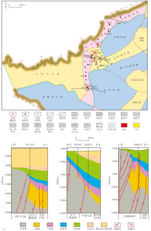
图1
研究区构造位置(a)及地质剖面(b)"

表1
研究区钻井数据"
| 井名 | 测温区间/ m | 静井时间/ d | 拟合系数 | 地温梯度/ (℃·km-1) | 岩石热导率/ (W·m-1·K-1) | 大地热流/ (mW·m-2) |
|---|---|---|---|---|---|---|
| JL2002井 | 300~4 230 | 18 | 0.999 | 21.7 | 2.11 | 45.6 |
| 白251井 | 100~2 700 | 26 | 0.999 | 22.8 | 2.18 | 49.6 |
| 百512井 | 100~1 230 | 12 | 0.994 | 20.3 | 2.04 | 41.3 |
| 车探1井 | 100~3 750 | 10 | 1.000 | 19.1 | 2.10 | 40.2 |
| 红832井 | 200~2 400 | 17 | 0.999 | 23.5 | 2.12 | 49.7 |
| 金209井 | 300~4 100 | 20 | 0.999 | 21.8 | 2.08 | 45.4 |
| 金龙108井 | 100~3 120 | 23 | 0.999 | 23.9 | 2.06 | 49.4 |
| 金龙11井 | 0~3 030 | 26 | 0.996 | 27.2 | 2.06 | 56.2 |
| 金龙20井 | 510~3 270 | 20 | 0.999 | 22.9 | 2.20 | 50.3 |
| 克016井 | 100~3 000 | 5 | 0.999 | 25.1 | 2.12 | 53.3 |
| 克88井 | 500~3 000 | 16 | 0.999 | 22.8 | 2.24 | 51.1 |
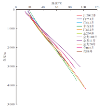
图2
研究区新增钻井温度随深度的变化曲线"


图3
研究区地温梯度平面分布"
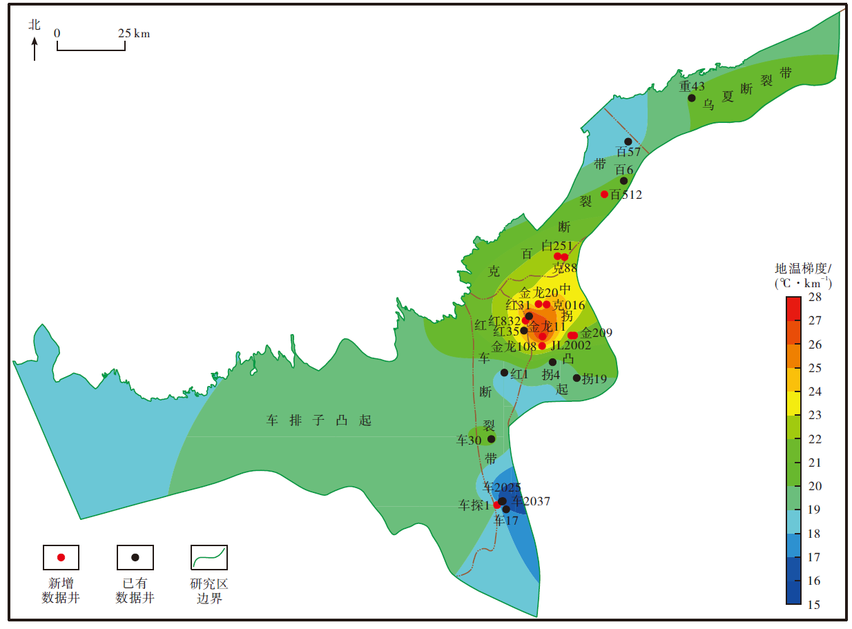
图4
研究区大地热流分布"

图5
研究区深度为1 000 m处地层温度平面分布"

图6
研究区深度为2 000 m处地层温度平面分布"


图7
研究区深度为3 000 m处地层温度平面分布"
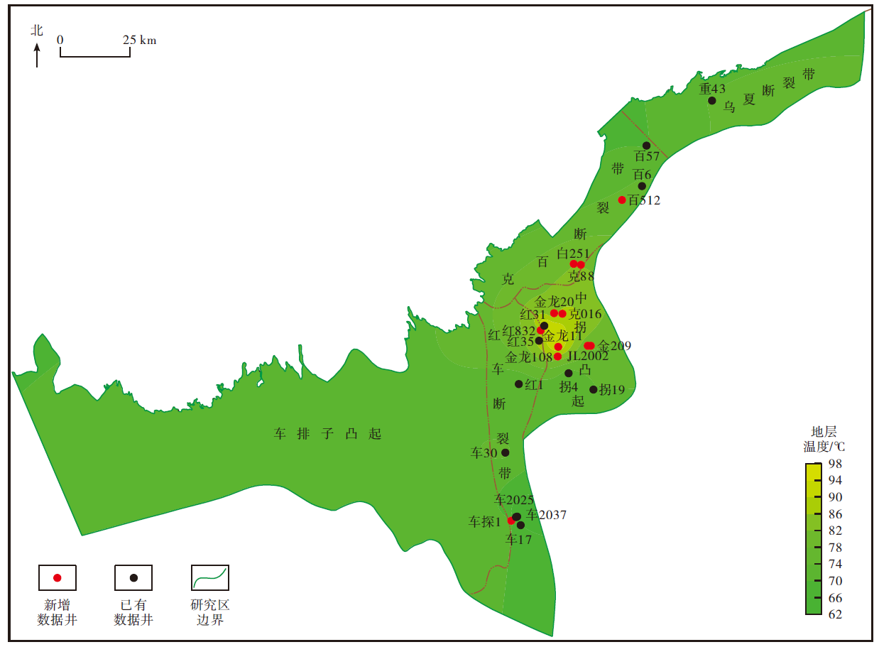

图8
研究区深度为4 000 m处地层温度平面分布"

图9
研究区深度为5 000 m处地层温度平面分布"

表2
研究区不同热储关键参数"
| 热储 | 深度/m | 热储面积/km2 | 热储厚度/m | 地层温度/℃ | 孔隙度/% |
|---|---|---|---|---|---|
| 新近系+第四系 | 19.3~141.2 | 4 756.88 | 38.7~282.3 | 18.0~20.8 | 0.10~39.67 |
| 古近系 | 6.4~2 197.8 | 4 837.92 | 12.8~52.5 | 18.1~61.1 | 0.10~33.22 |
| 白垩系 | 125.6~2 625.7 | 6 138.24 | 68.0~195.0 | 20.4~69.5 | 0.10~39.87 |
| 侏罗系 | 592.5~3 642.1 | 4 490.84 | 33.8~141.4 | 29.2~89.4 | 0.06~39.96 |
| 三叠系 | 1 277.4~4 247.0 | 3 515.76 | 88.1~110.4 | 42.1~101.2 | 0.03~36.69 |
| 二叠系 | 2 207.4~5 065.1 | 2 652.36 | 32.8~437.7 | 59.7~117.3 | 0.02~30.19 |
| 石炭系 | 3 308.6~7 979.5 | 8 796.12 | 50.0 | 76.6~174.4 | 0.05~32.80 |
表3
研究区不同热储地热资源量"
| 热储 | 岩石资源量 | 流体资源量 | 地热资源量 |
|---|---|---|---|
| 新近系+第四系 | 3.94 | 1.88 | 5.82 |
| 古近系 | 10.75 | 3.73 | 14.48 |
| 白垩系 | 35.50 | 19.58 | 55.08 |
| 侏罗系 | 30.84 | 9.25 | 40.09 |
| 三叠系 | 35.58 | 6.06 | 41.64 |
| 二叠系 | 115.72 | 16.89 | 132.61 |
| 石炭系 | 106.67 | 14.85 | 121.52 |
| 合计 | 339.00 | 72.24 | 411.24 |
| [1] | 汪集旸. 地热学及其应用[M]. 北京: 科学出版社, 2015. |
| WANG Jiyang. Geothermics and its applications[M]. Beijing: Science Press, 2015. | |
| [2] | 侯正猛, 吴旭宁, 罗佳顺, 等. 深部地热能系统主要挑战与耦合储能的增强型创新开发模式[J]. 煤田地质与勘探, 2024, 52(1):1-13. |
| HOU Zhengmeng, WU Xuning, LUO Jiashun, et al. Major challenges of deep geothermal systems and an innovative development mode of REGS integrated with energy storage[J]. Coal Geology & Exploration, 2024, 52(1):1-13. | |
| [3] | 庞忠和, 段忠丰. 华北赋煤区地热资源富集模式及开发利用方向[J]. 煤田地质与勘探, 2024, 52(9):14-22. |
| PANG Zhonghe, DUAN Zhongfeng. Accumulation patterns and exploitation and utilization targets of geothermal resources in the coal-bearing area in north China[J]. Coal Geology & Exploration, 2024, 52(9):14-22. | |
| [4] | 王贵玲, 陆川. 碳中和目标驱动下干热岩和增强型地热系统增产技术发展[J]. 地质与资源, 2023, 32(1):85-95. |
| WANG Guiling, LU Chuan. Stimulation technology development of hot dry rock and enhanced geothemal system driven by carbon neutrality target[J]. Geology and Resources, 2023, 32(1):85-95. | |
| [5] | 陈春瑞, 李晶, 王峥, 等. 松辽盆地北部地热资源分布特征及开发对策[J]. 大庆石油地质与开发, 2024, 43(4):215-222. |
| CHEN Chunrui, LI Jing, WANG Zheng, et al. Distribution characteristics and development strategy of geothermal resources in northern Songliao Basin[J]. Petroleum Geology & Oilfield Development in Daqing, 2024, 43(4):215-222. | |
| [6] | 熊波, 许浩, 唐淑玲, 等. 内蒙古中部干热岩地热资源成因机制研究[J]. 煤田地质与勘探, 2024, 52(1):36-45. |
| XIONG Bo, XU Hao, TANG Shuling, et al. Genetic mechanisms of hot dry rock geothermal resources in central Inner Mongolia[J]. Coal Geology & Exploration, 2024, 52(1):36-45. | |
| [7] | 夏国朝, 楼达, 赵艳婷, 等. 歧口凹陷区新近系馆陶组热储特征及成因机制[J]. 煤田地质与勘探, 2024, 52(1):46-55. |
| XIA Guochao, LOU Da, ZHAO Yanting, et al. Characteristics and genetic mechanism of geothermal reservoirs in the Neogene Guantao formation,Qikou sag[J]. Coal Geology & Exploration, 2024, 52(1):46-55. | |
| [8] | 邱楠生, 胡圣标, 何丽娟. 沉积盆地地热学[M]. 山东东营: 中国石油大学出版社, 2019. |
| QIU Nansheng, HU Shengbiao, HE Lijuan. Geothermal in sedimentary basin[M]. Dongying,Shandong: China University of Petroleum Press, 2019. | |
| [9] |
周总瑛, 刘世良, 刘金侠. 中国地热资源特点与发展对策[J]. 自然资源学报, 2015, 30(7):1210-1221.
doi: 10.11849/zrzyxb.2015.07.013 |
|
ZHOU Zongying, LIU Shiliang, LIU Jinxia. Study on the characteristics and development strategies of geothermal resources in China[J]. Journal of Natural Resources, 2015, 30(7):1210-1221.
doi: 10.11849/zrzyxb.2015.07.013 |
|
| [10] |
王社教, 李峰, 闫家泓, 等. 油田地热资源评价方法及应用[J]. 石油学报, 2020, 41(5):553-564.
doi: 10.7623/syxb202005004 |
|
WANG Shejiao, LI Feng, YAN Jiahong, et al. Evaluation methods and application of geothermal resources in oilfields[J]. Acta Petrolei Sinica, 2020, 41(5):553-564.
doi: 10.7623/syxb202005004 |
|
| [11] | 黄珣, 张云辉, 李晓, 等. 川西磨西断裂湾东地热水化学特征及成因机制[J]. 煤田地质与勘探, 2024, 52(6):91-101. |
| HUANG Xun, ZHANG Yunhui, LI Xiao, et al. Hydrochemical characteristics and genetic mechanism of geothermal water in the Wandong geothermal area along the Moxi fault in western Sichuan[J]. Coal Geology & Exploration, 2024, 52(6):91-101. | |
| [12] | 宋先知, 许富强, 宋国锋. 废弃井地热能开发技术现状与发展建议[J]. 石油钻探技术, 2020, 48(6):1-7. |
| SONG Xianzhi, XU Fuqiang, SONG Guofeng. Technical status and development suggestions in exploiting geothermal energy from abandoned wells[J]. Petroleum Drilling Techniques, 2020, 48(6):1-7. | |
| [13] | 胡霞, 吕建才, 张新成. 废弃油井直接换热技术及应用效果评价[J]. 地质与资源, 2020, 29(5):497-502. |
| HU Xia, LYU Jiancai, ZHANG Xincheng. Evaluation on application effects of direct heat exchange technology in abandoned oil wells[J]. Geology and Resources, 2020, 29(5):497-502. | |
| [14] | 杨永红, 杨万芹, 陈云华, 等. 济阳坳陷深层地热资源研究进展与下步展望[J]. 油气地质与采收率, 2024, 31(4):196-206. |
| YANG Yonghong, YANG Wanqin, CHEN Yunhua, et al. Research progress and prospects of deep geothermal resources in Jiyang depression[J]. Petroleum Geology and Recovery Efficiency, 2024, 31(4):196-206. | |
| [15] | 杨正大, 任铄文, 林日亿. 中深层地热开发利用技术研究进展[J]. 世界石油工业, 2025, 32(4):66-78. |
| YANG Zhengda, REN Shuowen, LIN Riyi. Progress of research on medium and deep geothermal development and utilisation technology[J]. World Petroleum Industry, 2025, 32(4):66-78. | |
| [16] | 刘永旺, 王红, 霍韵如, 等. 干热岩地热资源清洁化及效益化开发新方法[J]. 世界石油工业, 2025, 32(4):79-88. |
| LIU Yongwang, WANG Hong, HUO Yunru, et al. New method of clean and efficient development of hot dry rock geothermal resources[J]. World Petroleum Industry, 2025, 32(4):79-88. | |
| [17] | 王社教, 胡圣标, 汪集旸. 准噶尔盆地热流及地温场特征[J]. 地球物理学报, 2000, 43(6):771-779. |
| WANG Shejiao, HU Shengbiao, WANG Jiyang. The characteristics of heat flow and geothermal fields in Junggar Basin[J]. Chinese Journal of Geophysics, 2000, 43(6):771-779. | |
| [18] | 饶松, 胡圣标, 朱传庆, 等. 准噶尔盆地大地热流特征与岩石圈热结构[J]. 地球物理学报, 2013, 56(8):2760-2770. |
| RAO Song, HU Shengbiao, ZHU Chuanqing, et al. The characteristics of heat flow and lithospheric thermal structure in Junggar Basin,northwest China[J]. Chinese Journal of Geophysics, 2013, 56(8):2760-2770. | |
| [19] | 靳军, 刘明, 刘雨晨, 等. 准噶尔盆地南缘下组合现今温压场特征及其控制因素[J]. 地质科学, 2021, 56(1):28-43. |
| JIN Jun, LIU Ming, LIU Yuchen, et al. Present-day temperature-pressure field and its controlling factors of the lower composite reservoir in the southern margin of Junggar Basin[J]. Chinese Journal of Geology, 2021, 56(1):28-43. | |
| [20] |
JIANG Guangzheng, HU Shengbiao, SHI Yizuo, et al. Terrestrial heat flow of continental China:Updated dataset and tectonic implications[J]. Tectonophysics, 2019, 753:36-48.
doi: 10.1016/j.tecto.2019.01.006 |
| [21] | 唐博宁, 邱楠生, 朱传庆, 等. 松辽盆地岩石热导率柱及古地温场分布特征[J]. 煤田地质与勘探, 2024, 52(1):26-35. |
| TANG Boning, QIU Nansheng, ZHU Chuanqing, et al. Thermal conductivity column of rocks and distribution characteristics of paleo-geothermal field in the Songliao Basin[J]. Coal Geology & Exploration, 2024, 52(1):26-35. | |
| [22] | 饶松, 朱传庆, 廖宗宝, 等. 利用自然伽马测井计算准噶尔盆地沉积层生热率及其热流贡献[J]. 地球物理学报, 2014, 57(5):1554-1567. |
| RAO Song, ZHU Chuanqing, LIAO Zongbao, et al. Heat production rate and heat flow contribution of the sedimentary formation in Junggar Basin,northwest China[J]. Chinese Journal of Geophysics, 2014, 57(5):1554-1567. | |
| [23] | 何登发, 张磊, 吴松涛, 等. 准噶尔盆地构造演化阶段及其特征[J]. 石油与天然气地质, 2018, 39(5):845-861. |
| HE Dengfa, ZHANG Lei, WU Songtao, et al. Tectonic evolution stages and characteristics of the Junggar Basin[J]. Oil & Gas Geology, 2018, 39(5):845-861. | |
| [24] | 曲国胜, 马宗晋, 邵学钟, 等. 准噶尔盆地基底构造与地壳分层结构[J]. 新疆石油地质, 2008, 29(6):669-674. |
| QU Guosheng, MA Zongjin, SHAO Xuezhong, et al. Basements and crust structures in Junggar Basin[J]. Xinjiang Petroleum Geology, 2008, 29(6):669-674. | |
| [25] | 刘超威, 李辉, 王泽胜, 等. 准噶尔盆地阜康凹陷二叠系上乌尔禾组油气勘探突破与启示[J]. 新疆石油地质, 2024, 45(2):139-150. |
| LIU Chaowei, LI Hui, WANG Zesheng, et al. Breakthrough and implication of oil and gas exploration in Permian upper Wuerhe formation in Fukang sag,Junggar Basin[J]. Xinjiang Petroleum Geology, 2024, 45(2):139-150. | |
| [26] | 熊婷, 刘宇, 陈文利, 等. 准噶尔盆地沙湾凹陷西斜坡上乌尔禾组油藏成藏模式新认识[J]. 新疆石油地质, 2024, 45(2):151-162. |
| XIONG Ting, LIU Yu, CHEN Wenli, et al. New understanding of hydrocarbon accumulation model of upper Wuerhe formation on western slope of Shawan sag,Junggar Basin[J]. Xinjiang Petroleum Geology, 2024, 45(2):151-162. | |
| [27] | 谭开俊, 张帆, 赵应成, 等. 准噶尔盆地西北缘构造特征分段性对比分析[J]. 石油地质与工程, 2008, 22(2):1-6. |
| TAN Kaijun, ZHANG Fan, ZHAO Yingcheng, et al. Analysis of structural segmentation in the northwestern margin of Junggar Basin[J]. Petroleum Geology and Engineering, 2008, 22(2):1-6. | |
| [28] | 张欣欣, 高凤琳, 张旺, 等. 准噶尔盆地西北缘中拐凸起断裂发育特征及构造变形过程[J]. 科学技术与工程, 2018, 18(10):6-11. |
| ZHANG Xinxin, GAO Fenglin, ZHANG Wang, et al. Fault characteristics and deformation process of Zhongguai uplift in northwestern margin of Junggar Basin[J]. Science Technology and Engineering, 2018, 18(10):6-11. | |
| [29] |
朱明, 袁波, 梁则亮, 等. 准噶尔盆地周缘断裂属性与演化[J]. 石油学报, 2021, 42(9):1163-1173.
doi: 10.7623/syxb202109004 |
|
ZHU Ming, YUAN Bo, LIANG Zeliang, et al. Fault properties and evolution in the periphery of Junggar Basin[J]. Acta Petrolei Sinica, 2021, 42(9):1163-1173.
doi: 10.7623/syxb202109004 |
|
| [30] |
张超, 张盛生, 李胜涛, 等. 共和盆地恰卜恰地热区现今地热特征[J]. 地球物理学报, 2018, 61(11):4545-4557.
doi: 10.6038/cjg2018L0747 |
| ZHANG Chao, ZHANG Shengsheng, LI Shengtao, et al. Geothermal characteristics of the Qiabuqia geothermal area in the Gonghe Basin[J]. Chinese Journal of Geophysics, 2018, 61(11):4545-4557. | |
| [31] |
李春荣, 饶松, 胡圣标, 等. 川东南焦石坝页岩气区现今地温场特征[J]. 地球物理学报, 2017, 60(2):617-627.
doi: 10.6038/cjg20170216 |
| LI Chunrong, RAO Song, HU Shengbiao, et al. Present-day geothermal field of the Jiaoshiba shale gas area in southeast of the Sichuan Basin,SW China[J]. Chinese Journal of Geophysics, 2017, 60(2):617-627, | |
| [32] | ZHU Chuanqing, XU Tong, QIU Nansheng, et al. Distribution characteristics of the deep geothermal field in the Sichuan Basin and its main controlling factors[J]. Frontiers in Earth Science, 2022, 10:1-11. |
| [33] | LIU Yuchen, LIU Bo, FU Jian, et al. Surface heat flow,deep formation temperature,and lithospheric thickness of the different tectonic units in Tarim Basin,western China[J]. Lithosphere, 2022, 1:3873682. |
| [34] |
PANG Yumao, ZOU Kaizhen, GUO Xingwei, et al. Geothermal regime and implications for basin resource exploration in the Qaidam Basin,northern Tibetan Plateau[J]. Journal of Asian Earth Sciences, 2022, 239:105400.
doi: 10.1016/j.jseaes.2022.105400 |
| [35] | YU Qiang, REN Zhanli, LI Rongxi, et al. Paleogeotemperature and maturity evolutionary history of the source rocks in the Ordos Basin[J]. Geological Journal, 2017,52 (Supp.1):97-108. |
| [36] |
姜光政, 高堋, 饶松, 等. 中国大陆地区大地热流数据汇编(第四版)[J]. 地球物理学报, 2016, 59(8):2892-2910.
doi: 10.6038/cjg20160815 |
| JIANG Guangzheng, GAO Peng, RAO Song, et al. Compilation of heat flow data in the continental area of China(4th edition)[J]. Chinese Journal of Geophysics, 2016, 59(8):2892-2910. | |
| [37] | 多吉. 典型高温地热系统:羊八井热田基本特征[J]. 中国工程科学, 2003, 5(1):42-47. |
| DUO Ji. The basic characteristics of the typical high-temperature geothermal system:Yangbajing geothermal field[J]. Engineering sciences, 2003, 5(1):42-47. | |
| [38] | 曹远远, 陈飞, 赵斐, 等. 准噶尔盆地侏罗纪构造岩浆事件[J]. 新疆地质, 2020, 38(3):341-347. |
| CAO Yuanyuan, CHEN Fei, ZHAO Fei, et al. Jurassic tectonic-magmatic events in the Junggar Basin[J]. Xinjiang Geology, 2020, 38(3):341-347. | |
| [39] | 李根. 准噶尔盆地西北缘风城地区侏罗系沉积特征研究[D]. 吉林: 吉林大学, 2017. |
| LI Gen. Research on the Jurassic sedimentary characteristics in the Fengcheng area on the northwest margin of the Junggar Basin[D]. Jilin: Jilin University, 2017. | |
| [40] | 王贵玲, 张薇, 梁继运, 等. 中国地热资源潜力评价[J]. 地球学报, 2017, 38(4):449-459. |
| WANG Guiling, ZHANG Wei, LIANG Jiyun, et al. Evaluation of geothermal resources potential in China[J]. Acta Geoscientica Sinica, 2017, 38(4):449-459. |
| [1] | 黄立良, 邹阳, 杨勇强, 李广兴, 吴俊军, 姜振学, 刘新龙. 玛湖凹陷风城组二段页岩油层系伴生碱矿特征及沉积发育模式[J]. 新疆石油地质, 2026, 47(1): 11-19. |
| [2] | 吕厚宽, 张磊, 安志渊, 况昊, 豆方鹏, 李存, 潘浪. 玛湖凹陷—沙湾凹陷中—下二叠统富火山碎屑砂砾岩储层成因[J]. 新疆石油地质, 2026, 47(1): 20-30. |
| [3] | 陈绍蓉, 赵毅, 邹阳, 任海姣, 陈方文, 吴俊军. 玛湖凹陷风城组古沉积环境特征及其对页岩油甜点的影响[J]. 新疆石油地质, 2026, 47(1): 46-56. |
| [4] | 金之钧, 曹琰, 张虹, 唐勇, 秦志军, 刘扣其, 梁成钢, 李关访, 何文军. 吉木萨尔凹陷芦草沟组页岩油甜点主控因素研究与实践[J]. 新疆石油地质, 2025, 46(6): 647-658. |
| [5] | 曹剑, 秦志军, 魏超, 向宝力, 刘金. 陆相纹层型页岩油源储耦合与甜点形成机理——以准噶尔盆地风城组为例[J]. 新疆石油地质, 2025, 46(6): 668-683. |
| [6] | 刘金, 白雷, 张宝真, 魏超, 雷海艳, 邓远, 曹剑. 吉木萨尔凹陷芦草沟组页岩油微观赋存特征与开采动态响应[J]. 新疆石油地质, 2025, 46(6): 684-692. |
| [7] | 邹阳, 陈文顺, 罗刚, 陈绍蓉, 陈方文, 何文军, 刘新龙, 朱涛. 玛湖凹陷风城组碱湖页岩油富集和高产主控因素[J]. 新疆石油地质, 2025, 46(6): 693-702. |
| [8] | 魏兆胜, 齐洪岩, 赵建飞, 何吉祥, 刘可成, 王俊超. 准噶尔盆地页岩油开发进展及效益建产关键技术[J]. 新疆石油地质, 2025, 46(6): 703-711. |
| [9] | 刘向君, 甘仁忠, 熊健, 汤诗棋, 万有维, 周鑫, 梁利喜, 张淼. 吉木萨尔凹陷芦草沟组页岩油储层体积改造主控地质力学因素[J]. 新疆石油地质, 2025, 46(6): 723-733. |
| [10] | 李映艳, 丁艺, 罗刚, 丁怀宇, 唐慧莹, 贺戈. 基于地质工程一体化的井网-缝网协同优化——以准噶尔盆地吉木萨尔凹陷页岩油为例[J]. 新疆石油地质, 2025, 46(6): 742-753. |
| [11] | 杜雪彪, 张金风, 肖佃师, 冉阳, 刘英杰, 秦嘉敏, 王良哲. 基于ReliefF和LSBoost集成树核磁有效孔隙度频谱预测及分辨率匹配研究[J]. 新疆石油地质, 2025, 46(6): 762-772. |
| [12] | 姚菊琴, 陈刚, 唐廷明, 赵春雪, 李维, 余雪峰, 于江龙. 点复数谱提频方法在吉木萨尔页岩油甜点预测中的应用[J]. 新疆石油地质, 2025, 46(6): 773-778. |
| [13] | 齐洪岩, 王振林, 张艳宁, 蔺敬旗, 胡旋, 苏静, 徐睿, 曹志锋. 吉木萨尔凹陷芦草沟组页岩油藏甜点分类[J]. 新疆石油地质, 2025, 46(2): 127-135. |
| [14] | 杨旺旺, 王振林, 苏静, 胡旋, 黄玉越, 赖锦, 王贵文. 玛湖凹陷风城组页岩油赋存空间特征及可动性影响因素[J]. 新疆石油地质, 2025, 46(2): 192-200. |
| [15] | 黄后传, 曹晓璐, 李宁, 加玉锋, 吴国龙, 巨世昌. 金龙2井区致密油藏井间压窜识别及分析[J]. 新疆石油地质, 2025, 46(2): 201-207. |
| 阅读次数 | ||||||
|
全文 |
|
|||||
|
摘要 |
|
|||||