
Xinjiang Petroleum Geology ›› 2024, Vol. 45 ›› Issue (4): 489-498.doi: 10.7657/XJPG20240414
• APPLICATION OF TECHNOLOGY • Previous Articles Next Articles
CHEN Keyang1,2( ), ZHOU Hui1(), WANG Cheng2, LIU Yang2, LIU Jianying2, WANG Yangyang2, LIU Jishun2
Received:2024-03-21
Revised:2024-04-27
Online:2024-08-01
Published:2024-07-23
CLC Number:
CHEN Keyang, ZHOU Hui, WANG Cheng, LIU Yang, LIU Jianying, WANG Yangyang, LIU Jishun. 3D Seismic Imaging Technology and Its Application in GCD Work Area of Tarim Basin[J]. Xinjiang Petroleum Geology, 2024, 45(4): 489-498.
Add to citation manager EndNote|Reference Manager|ProCite|BibTeX|RefWorks
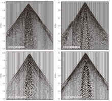
Fig. 1.
Common shot gathers and common receiver gathers at the top and bottom of sand dunes in the GCD work area"

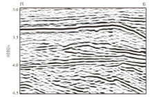
Fig. 2.
Profile processed by conventional imaging methods in the GCD work area"
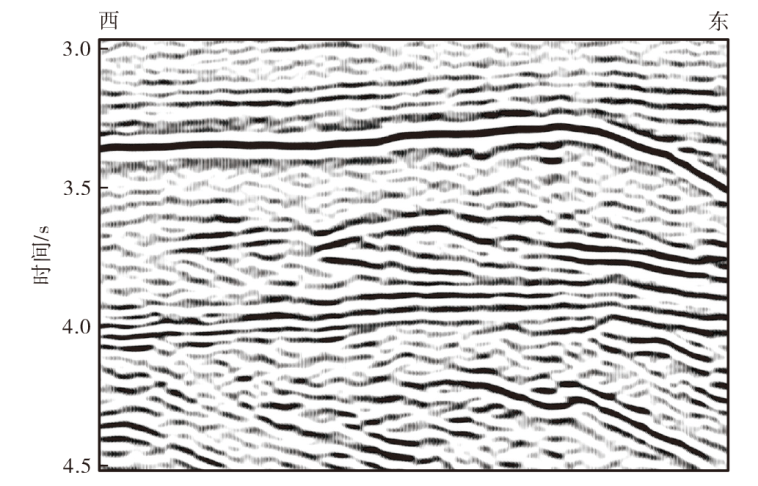
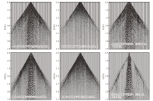
Fig. 3.
Gathers and residuals before and after denoising in the GCD work area"
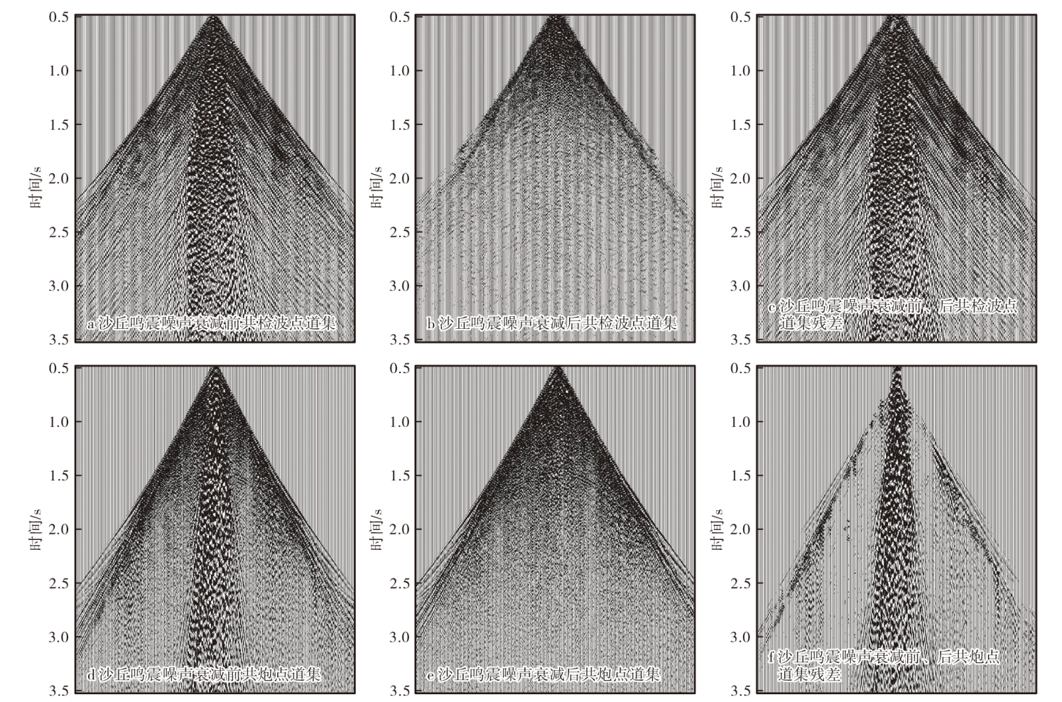
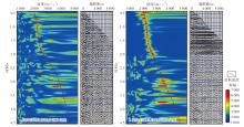
Fig. 4.
Velocity spectra and gathers before and after SNR enhancement in the GCD work area"

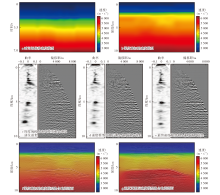
Fig. 5.
Velocity models, residual velocity spectra, and seismic profiles of the GCD work area"

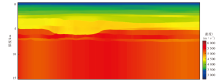
Fig. 6.
Multi-information-constrained anisotropic grid tomographic velocity model of the GCD work area"
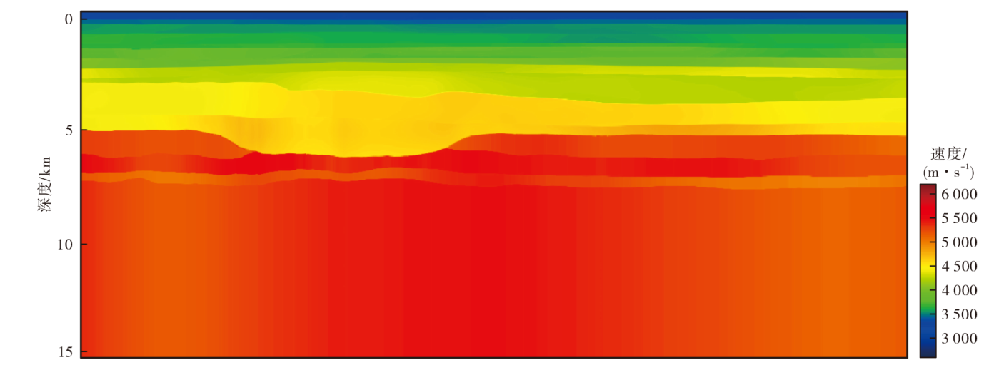
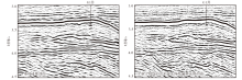
Fig. 7.
Imaging profiles through Well G1"
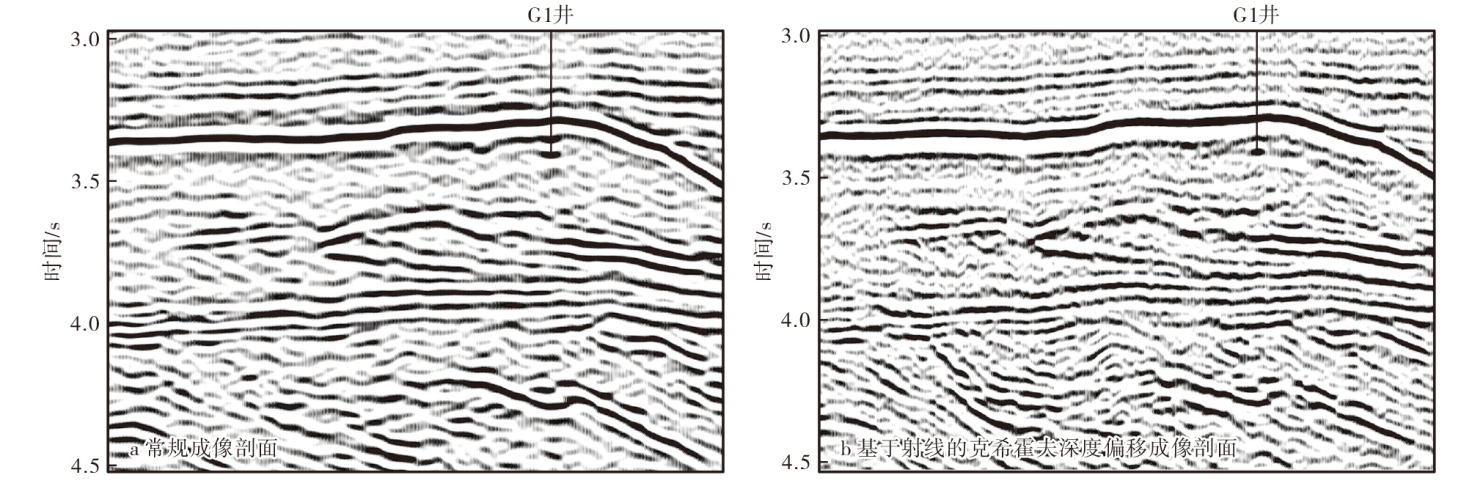
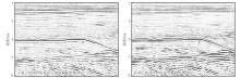
Fig. 8.
Profiles from different imaging methods"
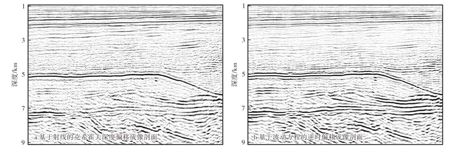
Fig. 9.
Bead-like energy along the upper Yingshan formation using different imaging methods"
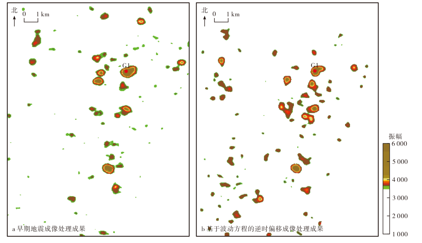

Fig. 10.
Fault depiction along the second member of the Yingshan formation using different imaging methods"
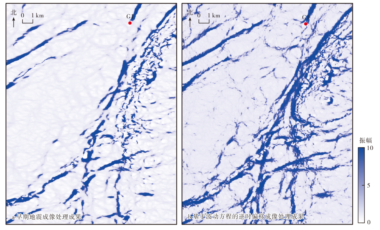

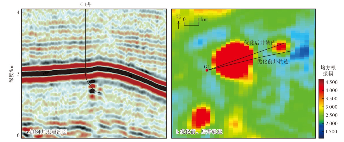
Fig. 11.
Seismic profile through Well G1 and well trajectory before and after optimization"
| [1] | 康玉柱. 塔里木盆地油气资源潜力及勘探方向[J]. 石油科学通报, 2018, 3(4):369-375. |
| KANG Yuzhu. The resource potential and exploration for oil and gas in the Tarim basin[J]. Petroleum Science Bulletin, 2018, 3(4):369-375. | |
| [2] | 焦方正. 塔里木盆地顺北特深碳酸盐岩断溶体油气藏发现意义与前景[J]. 石油与天然气地质, 2018, 39(2):207-216. |
| JIAO Fangzheng. Significance and prospect of ultra-deep carbonate fault-karst reservoirs in Shunbei area,Tarim basin[J]. Oil & Gas Geology, 2018, 39(2):207-216. | |
| [3] |
李阳, 薛兆杰, 程喆, 等. 中国深层油气勘探开发进展与发展方向[J]. 中国石油勘探, 2020, 25(1):45-57.
doi: 10.3969/j.issn.1672-7703.2020.01.005 |
|
LI Yang, XUE Zhaojie, CHENG Zhe, et al. Progress and development directions of deep oil and gas exploration and development in China[J]. China Petroleum Exploration, 2020, 25(1):45-57.
doi: 10.3969/j.issn.1672-7703.2020.01.005 |
|
| [4] |
潘建国, 李劲松, 王宏斌, 等. 深层—超深层碳酸盐岩储层地震预测技术研究进展与趋势[J]. 中国石油勘探, 2020, 25(3):156-166.
doi: 10.3969/j.issn.1672-7703.2020.03.014 |
|
PAN Jianguo, LI Jinsong, WANG Hongbin, et al. Research progress and trend of seismic prediction technology for deep and ultra-deep carbonate reservoir[J]. China Petroleum Exploration, 2020, 25(3):156-166.
doi: 10.3969/j.issn.1672-7703.2020.03.014 |
|
| [5] |
马永生, 蔡勋育, 云露, 等. 塔里木盆地顺北超深层碳酸盐岩油气田勘探开发实践与理论技术进展[J]. 石油勘探与开发, 2022, 49(1):1-17.
doi: 10.11698/PED.2022.01.01 |
| MA Yongsheng, CAI Xunyu, YUN Lu, et al. Practice and theoretical and technical progress in exploration and development of Shunbei ultra-deep carbonate oil and gas field,Tarim basin,NW China[J]. Petroleum Exploration and Development, 2022, 49(1):1-17. | |
| [6] |
李宗杰, 刘军, 张永升, 等. 塔里木盆地中石化探区油气勘探进展、难点及技术需求[J]. 石油物探, 2023, 62(4):579-591.
doi: 10.12431/issn.1000-1441.2023.62.04.001 |
|
LI Zongjie, LIU Jun, ZHANG Yongsheng, et al. Progress,difficulties,and technical requirements of oil and gas exploration of the Sinopec exploration area in the Tarim basin[J]. Geophysical Prospecting for Petroleum, 2023, 62(4):579-591.
doi: 10.12431/issn.1000-1441.2023.62.04.001 |
|
| [7] |
漆立新. 塔里木盆地顺北地区海相超深碳酸盐岩油气勘探物探技术需求与创新应用[J]. 石油物探, 2023, 62(3):381-394.
doi: 10.12431/issn.1000-1441.2023.62.03.001 |
|
QI Lixin. Technical demand and innovative application of geophysical exploration technology for marine ultra-deep carbonate rocks in Shunbei area,Tarim basin[J]. Geophysical Prospecting for Petroleum, 2023, 62(3):381-394.
doi: 10.12431/issn.1000-1441.2023.62.03.001 |
|
| [8] |
曹宏, 常德双, 胡少华, 等. 中国深层油气勘探地球物理技术与展望[J]. 石油学报, 2023, 44(12):2250-2269.
doi: 10.7623/syxb202312015 |
|
CAO Hong, CHANG Deshuang, HU Shaohua, et al. Geophysical techniques and prospects for deep oil-gas exploration in China[J]. Acta Petrolei Sinica, 2023, 44(12):2250-2269.
doi: 10.7623/syxb202312015 |
|
| [9] | 黄福喜, 汪少勇, 李明鹏, 等. 中国石油深层、超深层油气勘探进展与启示[J]. 天然气工业, 2024, 44(1):86-96. |
| HUANG Fuxi, WANG Shaoyong, LI Mingpeng, et al. Progress and implications of deep and ultra-deep oil and gas exploration in PetroChina[J]. Natural Gas Industry, 2024, 44(1):86-96. | |
| [10] |
李宗杰, 杨子川, 李海英, 等. 顺北沙漠区超深断溶体油气藏三维地震勘探关键技术[J]. 石油物探, 2020, 59(2):283-294.
doi: 10.3969/j.issn.1000-1441.2020.02.015 |
|
LI Zongjie, YANG Zichuan, LI Haiying, et al. Three-dimensional seismic exploration method for ultra-deep fault-related dissolution reservoirs in the Shunbei desert area[J]. Geophysical Prospecting for Petroleum, 2020, 59(2):283-294.
doi: 10.3969/j.issn.1000-1441.2020.02.015 |
|
| [11] | 陈可洋, 吴清岭, 林春华, 等. 含压实效应的沙丘曲线静校正方法及其应用[J]. 矿业工程研究, 2011, 26(4):53-57. |
| CHEN Keyang, WU Qingling, LIN Chunhua, et al. Sand dune curve static method considering compaction effect and its application[J]. Mineral Engineering Research, 2011, 26(4):53-57. | |
| [12] | 赵安, 陈可洋, 周学慧, 等. 塔里木盆地沙丘地表区保幅和高分辨率地震资料处理方法研究[J]. 长江大学学报(自科版), 2013, 10(4):71-75. |
| ZHAO An, CHEN Keyang, ZHOU Xuehui, et al. Amplitude-preserved high-resolution seismic data processing method in Tarim sand dune area[J]. Journal of Yangtze University(Natural Science Edition), 2013, 10(4):71-75. | |
| [13] | 钟铁, 陈云, 董新桐, 等. 基于DBBCNN的沙漠区地震资料随机噪声衰减方法[J]. 石油地球物理勘探, 2022, 57(2):268-278. |
| ZHONG Tie, CHEN Yun, DONG Xintong, et al. Research on random noise attenuation method for seismic data from deserts based on DBBCNN[J]. Oil Geophysical Prospecting, 2022, 57(2):268-278. | |
| [14] |
袁刚, 索重辉. 井炮地震数据的沙漠鸣震噪声特征分析与压制方法[J]. 石油物探, 2023, 62(6):1072-1079.
doi: 10.12431/issn.1000-1441.2023.62.06.007 |
|
YUAN Gang, SUO Chonghui. Propagation characteristics and suppression methods of sand dune ringing noises in common-receiver gathers[J]. Geophysical Prospecting for Petroleum, 2023, 62(6):1072-1079.
doi: 10.12431/issn.1000-1441.2023.62.06.007 |
|
| [15] |
杨金龙, 齐鹏, 沈向存, 等. 沙漠区地震资料层间多次波处理策略[J]. 石油物探, 2023, 62(6):1064-1071.
doi: 10.12431/issn.1000-1441.2023.62.06.006 |
|
YANG Jinlong, QI Peng, SHEN Xiangcun, et al. Processing strategy of internal multiples for desert seismic data[J]. Geophysical Prospecting for Petroleum, 2023, 62(6):1064-1071.
doi: 10.12431/issn.1000-1441.2023.62.06.006 |
|
| [16] | LIU Siqing, ZHOU Zhusheng, PENG Sanxi, et al. Improving the resolution of seismic data based on S-transform and modified variational mode decomposition,an application to Songliao basin,northeast China[J]. Acta Geophysica, 2022, 70(3):1103-1113. |
| [17] | 张高成, 魏华动, 商建立, 等. 塔里木盆地KDKZ3区块奥陶系成像处理关键技术应用[J]. 石油地质与工程, 2020, 34(2):39-43. |
| ZHANG Gaocheng, WEI Huadong, SHANG Jianli, et al. Application of key technologies for Ordovician imaging processing in KDKZ3 block of Tarim basin[J]. Petroleum Geology and Engineering, 2020, 34(2):39-43. | |
| [18] | 赵锐锐, 周强, 彭更新, 等. 塔里木盆地沙漠区超深层碳酸盐岩地震资料精细处理技术[J]. 物探化探计算技术, 2023, 45(6):717-725. |
| ZHAO Ruirui, ZHOU Qiang, PENG Gengxin, et al. Application of high-precision seismic processing technology for ultra-deep carbonate reservoir in the great desert area,Tarim basin,NW China[J]. Computing Techniques for Geophysical and Geochemical Exploration, 2023, 45(6):717-725. | |
| [19] | 陈可洋, 吴清岭, 李来林, 等. 松辽盆地三维地震资料连片处理关键技术及其应用效果分析[J]. 岩性油气藏, 2012, 24(2):87-91. |
| CHEN Keyang, WU Qingling, LI Lailin, et al. Key technology of 3D seismic data multi-survey joint processing and its application effect analysis in Songliao basin[J]. Lithologic Reservoirs, 2012, 24(2):87-91. | |
| [20] |
朱立华, 马灵伟, 白英哲, 等. 顺北超深断控体地震多信息约束速度建模[J]. 石油物探, 2019, 58(6):864-873.
doi: 10.3969/j.issn.1000-1441.2019.06.009 |
|
ZHU Lihua, MA Lingwei, BAI Yingzhe, et al. Velocity modeling of an ultra-deep fault-controlled reservoir in Shunbei area,China,using a multi-information constraint[J]. Geophysical Prospecting for Petroleum, 2019, 58(6):864-873.
doi: 10.3969/j.issn.1000-1441.2019.06.009 |
|
| [21] | 白英哲, 孙赞东, 周新源. Q偏移在塔里木盆地碳酸盐岩储层成像中的应用[J]. 石油地球物理勘探, 2011, 46(增刊1):7-11. |
| BAI Yingzhe, SUN Zandong, ZHOU Xinyuan. Kirchhoff prestack depth Q-migration and application in Tarim carbonate reservoirs[J]. Oil Geophysical Prospecting, 2011,46 (Supp.1):7-11. | |
| [22] |
李宗杰, 李海英, 王立歆, 等. 全方位局部角度域偏移成像技术在顺北油气田的应用[J]. 石油物探, 2023, 62(5):902-911.
doi: 10.12431/issn.1000-1441.2023.62.05.009 |
|
LI Zongjie, LI Haiying, WANG Lixin, et al. Application of full-azimuth local angle domain migration imaging technology to the Shunbei oilfield[J]. Geophysical Prospecting for Petroleum, 2023, 62(5):902-911.
doi: 10.12431/issn.1000-1441.2023.62.05.009 |
|
| [23] | 杨江峰, 刘定进, 朱文斌, 等. 逆时偏移技术在碳酸盐岩缝-洞储层成像中应用[J]. 高校地质学报, 2014, 20(2):303-308. |
| YANG Jiangfeng, LIU Dingjin, ZHU Wenbin, et al. Technique and application of reverse time migration of fractured-vuggy carbonate reservoir[J]. Geological Journal of China Universities, 2014, 20(2):303-308. | |
| [24] | 刘剑鹰, 李平和, 张正立, 等. 沙漠地区弱反射地震资料处理成像技术研究[J]. 石油地质与工程, 2016, 30(4):14-17. |
| LIU Jianying, LI Pinghe, ZHANG Zhengli, et al. Research on weak reflection seismic data processing and imaging technology in desert areas[J]. Petroleum Geology and Engineering, 2016, 30(4):14-17. | |
| [25] |
王立歆, 李海英, 李弘, 等. 复杂地质条件下超深层碳酸盐岩断控缝洞体成像及预测技术[J]. 石油物探, 2022, 61(5):865-875.
doi: 10.3969/j.issn.1000-1441.2022.05.011 |
|
WANG Lixin, LI Haiying, LI Hong, et al. Imaging and prediction technology of fault-karst reservoirs in ultra-deep carbonate rocks under complex geological conditions[J]. Geophysical Prospecting for Petroleum, 2022, 61(5):865-875.
doi: 10.3969/j.issn.1000-1441.2022.05.011 |
|
| [26] | 韩革华, 漆立新, 李宗杰, 等. 塔河油田奥陶系碳酸盐岩缝洞型储层预测技术[J]. 石油与天然气地质, 2006, 27(6):860-870. |
| HAN Gehua, QI Lixin, LI Zongjie, et al. Prediction of the Ordovician fractured-vuggy carbonate reservoirs in Tahe oilfield[J]. Oil & Gas Geology, 2006, 27(6):860-870. | |
| [27] | 张向全, 谷永兴, 刘军, 等. 库车坳陷秋里塔格构造带西段高精度地震成像[J]. 新疆石油地质, 2023, 44(5):626-633. |
| ZHANG Xiangquan, GU Yongxing, LIU Jun, et al. High-precision seismic imaging of western Qiulitag structural belt in Kuqa depression[J]. Xinjiang Petroleum Geology, 2023, 44(5):626-633. | |
| [28] | 吴梅莲, 柴雄, 周碧辉, 等. 缝洞型碳酸盐岩储集层连通性刻画及应用[J]. 新疆石油地质, 2022, 43(2):188-193. |
| WU Meilian, CHAI Xiong, ZHOU Bihui, et al. Connectivity characterization of fractured-vuggy carbonate reservoirs and application[J]. Xinjiang Petroleum Geology, 2022, 43(2):188-193. | |
| [29] | 田军, 王清华, 杨海军, 等. 塔里木盆地油气勘探历程与启示[J]. 新疆石油地质, 2021, 42(3):272-282. |
| TIAN Jun, WANG Qinghua, YANG Haijun, et al. Petroleum exploration history and enlightenment in Tarim basin[J]. Xinjiang Petroleum Geology, 2021, 42(3):272-282. | |
| [30] | 杨威, 周刚, 李海英, 等. 碳酸盐岩深层走滑断裂成像技术[J]. 新疆石油地质, 2021, 42(2):246-252. |
| YANG Wei, ZHOU Gang, LI Haiying, et al. Seismic imaging technology for deep strike-slip faults in carbonate reservoirs[J]. Xinjiang Petroleum Geology, 2021, 42(2):246-252. | |
| [31] | 张远银, 孙赞东, 杨海军, 等. 基于纯纵波地震资料的碳酸盐岩储集层识别[J]. 新疆石油地质, 2020, 41(5):605-611. |
| ZHANG Yuanyin, SUN Zandong, YANG Haijun, et al. Carbonate reservoir identification based on pure P-wave data[J]. Xinjiang Petroleum Geology, 2020, 41(5):605-611. | |
| [32] | 陈可洋. 逆时成像技术在大庆探区复杂构造成像中的应用[J]. 岩性油气藏, 2017, 29(6):91-100. |
| CHEN Keyang. Application of reverse-time migration technology to complex structural imaging in Daqing exploration area[J]. Lithologic Reservoirs, 2017, 29(6):91-100. | |
| [33] | 陈可洋. 地震波逆时偏移成像效果提升方法及应用[J]. 大庆石油地质与开发, 2018, 37(4):140-145. |
| CHEN Keyang. Improving method of the seismic-wave reverse-time migration imaged effects and its application[J]. Petroleum Geology & Oilfield Development in Daqing, 2018, 37(4):140-145. |
| [1] | WANG Qinghua, CAI Zhenzhong, ZHANG Yintao, WU Guanghui, XIE Zhou, WAN Xiaoguo, TANG Hao. Research Progress and Trend of Ultra-Deep Strike-Slip Fault-Controlled Hydrocarbon Reservoirs in Tarim Basin [J]. Xinjiang Petroleum Geology, 2024, 45(4): 379-386. |
| [2] | YANG Haijun, NENG Yuan, SHAO Longfei, XIE Zhou, KANG Pengfei, YUAN Jingyi, FU Yonghong. Multilayer Superimposition Patterns of Strike-Slip Fault Zones and Their Petroleum Geological Significance in Platform Area, Tarim Basin [J]. Xinjiang Petroleum Geology, 2024, 45(4): 387-400. |
| [3] | CAI Zhenzhong, LI Bing, LUO Xiao, LI Huiyuan, LI Mengqin, LI Zhengyang, WANG Qinghong. Ordovician Differential Deformation Mechanism of Northern Section of FⅠ17 Strike-Slip Fault, Tarim Basin [J]. Xinjiang Petroleum Geology, 2024, 45(4): 401-408. |
| [4] | BAI Bingchen, WU Guanghui, MA Bingshan, ZHAO Xingxing, TANG Hao, SHEN Chunguang, WANG Xupeng. Segmented Structural Characteristics and Growth Mechanism of Transtensional Strike-Slip Fault Zone in Tazhong Uplift [J]. Xinjiang Petroleum Geology, 2024, 45(4): 409-416. |
| [5] | XIONG Chang, SHEN Chunguang, ZHAO Xingxing, ZHAO Longfei, LI Shengqian, ZHOU Jie, PAN Tiancou. Segmentation of Strike-Slip Faults and Its Controls on Hydrocarbon Accumulation in Tarim Basin: A Case Study of FⅠ17 Strike-Slip Fault Zone [J]. Xinjiang Petroleum Geology, 2024, 45(4): 417-424. |
| [6] | DU Zhongyuan, LI Xiangwen, LI Qinglin, SUN Chong, LI Mohan, ZHANG Guanqing, DAN Guangjian. Differential Controls of Strike-Slip Faults of Different Orders on Carbonate Reservoirs [J]. Xinjiang Petroleum Geology, 2024, 45(4): 425-431. |
| [7] | ZHU Yongfeng, ZHANG Yanqiu, YANG Xinying, YANG Guang, PENG Debing, HAN Yu, WANG Zhenyu. Types and Distribution of Grain Shoals in Yijianfang Formation of Fuman Area, Tarim Basin [J]. Xinjiang Petroleum Geology, 2024, 45(4): 432-441. |
| [8] | LIU Qiang, LI Jing, LI Ting, ZHENG Mingjun, XU Mengjia, WANG Xuan, WU Mingyang. Oil-Water Two-Phase Flow Behaviors in Fracture-Cavity Carbonate Reservoirs With Fluid-Solid Coupling [J]. Xinjiang Petroleum Geology, 2024, 45(4): 451-459. |
| [9] | ZHANG Rujie, CHEN Lixin, YUE Ping, XIAO Yun, WANG Xia, LYU Yuan, YANG Wenming. Dynamic Model and Sensitivity Analysis of High-Pressure Water Injection for Capacity Expansion of Fractured-Vuggy Reservoirs [J]. Xinjiang Petroleum Geology, 2024, 45(4): 460-469. |
| [10] | HUANG Zhaoting, LI Chuntao, WANG Bin, QIAO Xia, FU Ying, YAN Bingxu. Enhanced Recovery in Middle and Late Stages of Depletion Development of Condensate Gas Reservoirs With Oil Ring [J]. Xinjiang Petroleum Geology, 2024, 45(4): 470-474. |
| [11] | WANG Rujun, SUN Chong, YUAN Jingyi, LIU Ruidong, WANG Xuan, MA Yinglong, WANG Xupeng. Seismic Identification of Strike-Slip Fault Damage Zones Based on Structure Tensor Analysis: A Case Study of Ultra-Deep Carbonate Rocks in Fuman Oilfield [J]. Xinjiang Petroleum Geology, 2024, 45(4): 475-482. |
| [12] | ZENG Yongjian, GAO Hongliang, GUAN Baozhu, AI Mingbo, CAI Quan, LI Fei, WANG Zhangheng. Application of Multi-Attribute Constrained Prestack Wide-Azimuth Fracture Prediction in Yingmai-2 Area [J]. Xinjiang Petroleum Geology, 2024, 45(4): 483-488. |
| [13] | GENG Jie, YUE Ping, YANG Wenming, YANG Bo, ZHAO Bin, ZHANG Rujie. Dynamic Reserves Calculation Method for Fault-Controlled Carbonate Reservoirs [J]. Xinjiang Petroleum Geology, 2024, 45(4): 499-504. |
| [14] | MAO Rui, BAI Yu, WANG Pan, HUANG Zhiqiang. Identification of Fluid in Highly Saline Tight Reservoirs of Fengcheng Formation in Maxi Slope Area [J]. Xinjiang Petroleum Geology, 2024, 45(3): 279-285. |
| [15] | ZHU Yue, WU Shunwei, DENG Yusen, LIU Lin, LEI Xianghui, NIU Youmu. Pore Throat Structures and Fluid Occurrences of Reservoirs in Fengcheng Formation, Mahu Sag [J]. Xinjiang Petroleum Geology, 2024, 45(3): 286-295. |
| Viewed | ||||||
|
Full text |
|
|||||
|
Abstract |
|
|||||