| [1] |
苟量, 贺振华. 西部复杂山地勘探走势分析[J]. 石油地球物理勘探, 2005, 40(2):248-251.
|
|
GOU Liang, HE Zhenhua. Analysis of trend to complex mountainous exploration in west of China[J]. Oil Geophysical Prospecting, 2005, 40(2):248-251.
|
| [2] |
方勇, 罗文山, 姜翠苹, 等. 库车山地地震资料层析静校正方法的应用[J]. 石油地球物理勘探, 2017, 52(增刊1):23-27.
|
|
FANG Yong, LUO Wenshan, JIANG Cuiping, et al. Tomo-statics for Kuqa seismic data[J]. Oil Geophysical Prospecting, 2017, 52(Supp. 1):23-27.
|
| [3] |
冯泽元, 李培明, 唐海忠, 等. 利用层析反演技术解决山地复杂区静校正问题[J]. 石油物探, 2005, 44(3):284-287.
|
|
FENG Zeyuan, LI Peiming, TANG Haizhong, et al. Sloving the static correction problem in mountain complex block using tomographic inversion[J]. Geophysical Prospecting for Petroleum, 2005, 44(3):284-287.
|
| [4] |
伍泽云. 零入射角地震资料在 HX 地区薄储层预测中的应用[J]. 特种油气藏, 2022, 29(4):76-83.
doi: 10.3969/j.issn.1006-6535.2022.04.010
|
|
WU Zeyun. Application of zero-incidence-angle seismic data to thin reservoir prediction in HX area[J]. Special Oil & Gas Reserviors, 2022, 29(4):76-83.
|
| [5] |
李奎周, 郑绪瑭, 赵海波, 等. 基于波形分解的重构地震数据体技术在致密油薄储层预测中的应用[J]. 大庆石油地质与开发, 2022, 41(4):131-137.
|
|
LI Kuizhou, ZHENG Xutang, ZHAO Haibo, et al. Application of reconstructed seismic data volume technology based on waveform decomposition in prediction of thin tight oil reservoir[J]. Petroleum Geology & Oilfield Development in Daqing, 2022, 41(4):131-137.
|
| [6] |
赵长永, 陈希光, 李俊飞, 等. 基于三维地震数据的短期旋回内薄层砂体的预测[J]. 特种油气藏, 2023, 30(6):40-47.
doi: 10.3969/j.issn.1006-6535.2023.06.006
|
|
ZHAO Changyong, CHEN Xiguang, LI Junfei, et al. Application in the prediction of thin sand body within short-term sequence cycle based on 3D seismic data[J]. Special Oil & Gas Reservoirs, 2023, 30(6):40-47.
|
| [7] |
梁向豪, 李书君, 吴超, 等. 库车大北构造带三维叠前深度偏移处理解释技术[J]. 中国石油勘探, 2011, 16(5/6):8-13.
|
|
LIANG Xianghao, LI Shujun, WU Chao, et al. 3D prestack depth processing and interpretation in Dabei structure belt,Kuqa depression[J]. China Petroleum Exploration, 2011, 16(5/6):8-13.
|
| [8] |
钱荣均. 复杂地表区时深转换和深度偏移中基准面的问题[J]. 石油地球物理勘探, 1999, 34(6):691-694.
|
|
QIAN Rongjun. The datum probleum of time-depth conversion and depth migration in complicated-surface area[J]. Oil Geophysical Prospecting, 1999, 34(6):691-694.
|
| [9] |
耿建华, 黄海贵, 马在田. Kirchhoff 积分波场延拓基准面静校正方法研究[J]. 同济大学学报, 1996, 24(6):665-669.
|
|
GENG Jianhua, HUANG Haigui, MA Zaitian. Kirchhoff wavefield extrapolation datuming[J]. Journal of Tongji University, 1996, 24(6):665-669.
|
| [10] |
蔡杰雄, 杨锴. TDO基准面校正方法研究与应用[J]. 石油地球物理勘探, 2008, 43(4):397-400.
|
|
CAI Jiexiong, YANG Kai. Study and application of TDO datum correction[J]. Oil Geophysical Prospecting, 2008, 43(4):397-400.
|
| [11] |
刘定进, 刘志成, 蒋波. 面向复杂山前带的深度域地震成像处理研究[J]. 石油物探, 2016, 55(1):49-59.
doi: 10.3969/j.issn.1000-1441.2016.01.007
|
|
LIU Dingjin, LIU Zhicheng, JIANG Bo. The processing workflow of depth domain imaging facing the complex piedmont belt[J]. Geophysical Prospecting for Petroleum, 2016, 55(1):49-59.
doi: 10.3969/j.issn.1000-1441.2016.01.007
|
| [12] |
冯许魁. 山前复杂高陡构造地震成像关键技术[D]. 成都: 成都理工大学, 2015.
|
|
FENG Xukui. The key imaging technology in complex piedmont structure exploration[D]. Chengdu: Chengdu University of Technology, 2015.
|
| [13] |
张继国, 刘连升. 复杂区初至层析反演静校正[J]. 石油地球物理勘探, 2006, 41(4):383-385.
|
|
ZHANG Jiguo, LIU Liansheng. Static corrections by first breaks tomographic inversion in complex area[J]. Oil Geophysical Prospecting, 2006, 41(4):383-385.
|
| [14] |
秦宁, 李振春, 桑运云, 等. 初至波走时层析速度建模方法研究[J]. 地球物理学进展, 2014, 29(1):225-260.
|
|
QIN Ning, LI Zhenchun, SANG Yunyun, et al. The research of travel time tomographic velocity modeling method on first break[J]. Progress in Geophysics, 2014, 29(1):255-260.
|
| [15] |
赵烽帆, 马婷, 徐涛. 地震波初至走时的计算方法综述[J]. 地球物理学进展, 2014, 29(3):1102-1113.
|
|
ZHAO Fengfan, MA Ting, XU Tao. A review of the travel-time calculation methods of seismic first break[J]. Progress in Geophysics, 2014, 29(3):1102-1113.
|
| [16] |
戴海涛, 成剑冰, 王红博, 等. 复杂地表浅层速度建模技术研究及应用[J]. 石油物探, 2020, 59(3):336-343.
doi: 10.3969/j.issn.1000-1441.2020.03.002
|
|
DAI Haitao, CHENG Jianbing, WANG Hongbo, et al. A shallow velocity modeling technique for complex surfaces[J]. Geophysical Prospecting for Petroleum, 2020, 59(3):336-343.
doi: 10.3969/j.issn.1000-1441.2020.03.002
|
| [17] |
阿力甫江·热合木吐力, 潘龙, 李献民, 等. 基于双平方根算子的速度建模方法及应用[J]. 新疆石油地质, 2023, 44(1):119-124.
|
|
Alifjian REHMTULY, PAN Long, LI Xianmin, et al. Development and application of velocity modeling method based on double square root operator[J]. Xinjiang Petroleum Geology, 2023, 44(1):119-124.
|
| [18] |
韩复兴, 孙建国, 孙章庆. 波前构建法研究现状[J]. 地球物理学进展, 2011, 26(3):1045-1051.
|
|
HAN Fuxing, SUN Jianguo, SUN Zhangqing. Research status of the wavefront construction method[J]. Progress in Geophysics, 2011, 26(3):1045-1051.
|
| [19] |
赵玲芝, 冯许魁, 祖云飞, 等. 复杂地表区叠前深度偏移近地表速度应用技术研究[J]. 地球物理学进展, 2018, 33(3):1176-1183.
|
|
ZHAO Lingzhi, FENG Xukui, ZU Yunfei, et al. Applied research of the complex near-surface velocity in the depth migration[J]. Progress in Geophysics, 2018, 33(3):1176-1183.
|
| [20] |
张向全, 谷永兴, 刘军, 等. 库车坳陷秋里塔格构造带西段高精度地震成像[J]. 新疆石油地质, 2023, 44(5):626-633.
|
|
ZHANG Xiangquan, GU Yongxing, LIU Jun, et al. High-precision seismic imaging of western Qiulitag structural belt in Kuqa depression[J]. Xinjiang Petroleum Geology, 2023, 44(5):626-633.
|
| [21] |
黄丽娟, 罗文山, 方勇, 等. 天山南北复杂构造成像技术进展及应用效果[J]. 新疆石油地质, 2020, 41(1):114-119.
|
|
HUANG Lijuan, LUO Wenshan, FANG Yong, et al. Progress and application of imaging technology for complex structures in the southern and northern Tianshan mountains[J]. Xinjiang Petroleum Geology, 2020, 41(1):114-119.
|
| [22] |
吴超, 许安明, 尚江伟, 等. TTI各向异性叠前深度偏移技术在库车复杂山地的应用[J]. 新疆石油地质, 2019, 40(1):103-107.
|
|
WU Chao, XU Anming, SHANG Jiangwei, et al. Application of TTI anisotropic prestack depth migration technology in complex mountain areas of Kuqa depression[J]. Xinjiang Petroleum Geology, 2019, 40(1):103-107.
|
| [23] |
巫芙蓉, 郭海洋, 刁永波, 等. 塔里木盆地秋里塔格构造带双复杂构造地震处理技术[J]. 天然气工业, 2019, 39(4):28-36.
|
|
WU Furong, GUO Haiyang, DIAO Yongbo, et al. Seismic processing technologies for double complex structures in the Qiulitage structural belt,Tarim basin[J]. Natural Gas Industry, 2019, 39(4):28-36.
|
| [24] |
熊晶璇, 贺振华, 刘鸿, 等. 山地复杂构造区叠前深度偏移初始层速度约束反演改进新方法[J]. 天然气工业, 2022, 42(5):47-55.
|
|
XIONG Jingxuan, HE Zhenhua, LIU Hong, et al. An improved constrained initial layer velocity inversion method for pre-stack depth migration in mountainous complex structure areas[J]. Natural Gas Industry, 2022, 42(5):47-55.
|
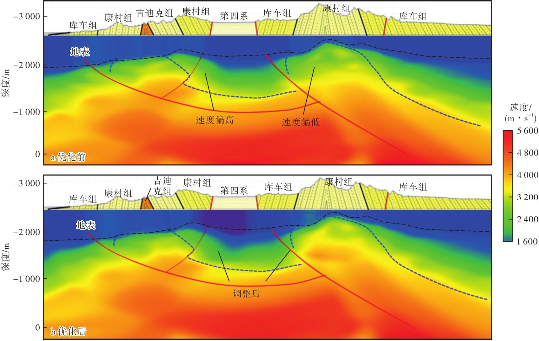
 ), 顾小弟2, 段文胜1, 公亭2, 赵锐锐1, 王勍2